Victorian Resources Online (archived)
Soil/Landform Unit 63
 On cleared areas, weeds such as blackberries and ragwort become a problem |
1.07% of CMA region From Upper Gellibrand to Peters Hill, steep spurs and ridges with long straight slopes and narrow valleys form the rugged northern margin of the Otway Range. The climate is significantly drier than in other parts of the range, with most areas receiving an annual rainfall of about 900 mm. The separation of these drier spurs and ridges from the rest of the range is well reflected by changes in the structure and composition of the native vegetation. In particular, Eucalyptus radiata becomes a prominent member the dominant stratum and the understorey changes from mesophytic species to drier sclerophyllous species such as Acacia mucronata, A. verticillata, Cassini longifolia and Epacris impressa. Most of this unit remains forested and is selectively logged for millable timber. Some parts of the eastern areas have been cleared for grazing, but management is difficult due to the rugged terrain. Softwood plantations have also been established. Landslips and sheet erosion have been severe in some areas, and rapid runoff from these hills creates problems of gully erosion on the plains of the Barwon River. | 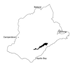 |
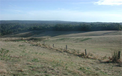
 Deeply dissected hills with rounded crests |  |
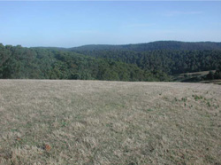
 | 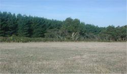 Pine plantation along the plateau of deeply dissected hills |
Component | 1 | 2 | 3 | 4 | 5 |
Proportion of soil-landform unit | 10% | 50% | 4% | 35% | 1% |
| CLIMATE Rainfall (mm) | Annual: 900-1100, lowest January (45), highest August (130) | ||||
| Temperature (oC) | Annual: 12, lowest July (7), highest February (17) | ||||
| Seasonal growth limitations | Precipitation: less than potential evapotranspiration mid Nomver - mid March | ||||
| GEOLOGY Age and lithology | |||||
| Geomorphology | |||||
| LANDUSE | Uncleared areas: Hardwood forestry for sawlogs, posts and poles; softwood forestry; nature conservation; active and passive recreation; water supply Minor cleared areas: Beef cattle grazing on mainly unimproved pastures | ||||
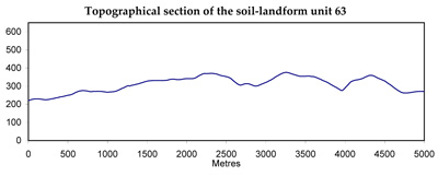
| TOPOGRAPHY Landscape | Deeply dissected hills of the Otway Range | ||||
| Elevation range (m) | 150-400 | ||||
| Local relief (m) | 150 | ||||
| Drainage pattern | Dendritic | ||||
| Drainage density (km/km2) | 2.7 | ||||
| Landform | Hills | ||||
| Landform element | Steep slope | North and west facing slopes | Crest and upper slope | South and east facing slopes | Lower slope and drainage lines |
| Slope and range (%) | 60 (20-70) | 45 (25-65) | 20 (5-3) | 45 (25-65) | 20 (1-35) |
| Slope shape | Linear | Linear | Convex | Linear | Concave |
| NATIVE VEGETATION Structure | Woodland | Open forest | Open forest | Tall open forest | Tall open forest |
| Dominant species | E. radiata, E. cypellocarpa | E. obliqua, E. radiata, E. cypellocarpa | E. obliqua, E. radiata, E. cypellocarpa | E. cypellocarpa, E. obliqua | E. cypellocarpa, E. obliqua, E. ovata, Acacia melanoxylong |
| SOIL Parent material | Colluvium | In situ weathered sandstone on conglomerate | In situ weathered sandstone on conglomerate | In situ weathered sandstone on conglomerate | Alluvium colluvium |
| Description (Corangamite Soil Group) | |||||
| Soil type sites | OTR732 | ||||
| Surface texture | Fine sandy loam | Loam | Loam | Loam | Silty loam |
| Permeability | Very high | Moderate | Moderate | High | High |
| Depth (m) | 0.5 | 0.9 | 0.9 | 0.9 | >2 |
| LAND CHARACTERISTICS, POTENTIAL AND LIMITATIONS | Stony shallow soils with weak structure and low waterholding capacity on steep slopes are prone to sheet erosion and landslips. | Dry aspect, steep slopes and weakly structured surfaces lead to sheet erosion. Clay subsoils on steep slopes subject to periodic saturation are prone to landslips. | Steeper slopes are prone to sheet erosion. | Steep slopes are prone to sheet erosion. Clay subsoils on steep slopes subject to periodic saturation are prone to landslips. | Weakly structured soils receiving runoff are prone to scour gullying siltation and flooding. |