Tarravale (Symbol: Tv)
EG25 | EG217
Geology
Devonian marine sediments, predominantly limestone. This map unit is mostly confined to the geological map unit known as the Taravale Formation, described as marlstone. The other two limestone formations, known as the Buchan Formation and the Murrindal Formation, have been combined in this report and called the Buchan map unit. The underlying rocks are classified as recrystallised limestone and are much harder than the marlstone.
Landform
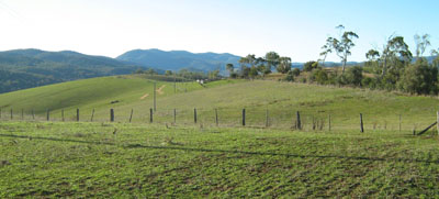
Rolling low hills to steep hills with an elevation range of about 80 to 350 m. The relief is less than 300 m with much of the land having lower relief of less than 90 m. Most of the area comprises long moderately inclined slopes with small areas of alluvial fans and drainage lines.
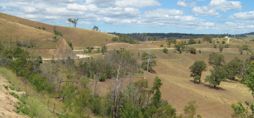
Rolling and steep hills on limestone north of Buchan
| Native vegetation Grassy woodland. Soils Component 1: Soils on long moderately inclined slopes. The soils of this map unit are quite variable in terms of colour, depth, and presence of stone above the marlstone. There may be some relationship between slope and aspect, but this could not be determined during this study. Other than the photographs of the pits, the following photographs show some of this variability. Most soils are alkaline and since lime occurs within the root zone, are unlikely to show any response to additional lime. Component 2: Soils on alluvial fans and drainage lines. No soils were examined. | 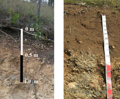 Left photo: Shallow dark brown soil Right photo: Deep red-brown soil on marlstone |
Site EG25
| Location: Buchan Township | Geo. Ref. 603500E 5849100N |
| Australian soil classification: Haplic, Calcic, Brown DERMOSOL | Brown gradational soil on limestone |
| General landscape description: Steep hills | |
| Geology: Devonian limestone | |
| Site description: Mid slope, NE aspect, 27% slope | |
| Land use: Road reserve | |
| Native vegetation: Grassy woodland | |
| Map unit: Taravale (Component 1) |
Soil profile morphology
| Surface soil | 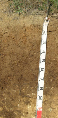 | ||
| A | 0 – 25 cm | Very dark brown (7.5YR4/2); clay loam (sub plastic); strong medium polyhedral structure; moderate amount (20-50%) subangular limestone pebbles (6 – 20 mm); clear change to: | |
| Subsoil | |||
| B | 25 – 65 cm | Dark brown (7.5YR4/3); heavy clay; strong medium prismatic parting to fine prismatic structure; common (10-20%) subangular limestone pebbles (6 – 20 mm; abrupt change to: | |
| C | 65– 85+ cm | Light yellowish brown (10YR6/4) rubbly limestone. | |
Key profile features
| |||
Soil profile characteristics
| pH | Salinity rating | Sodicity | Dispersion | Slaking | |
| Surface soil (A horizon) | Moderately acid | Very low | Non sodic | None | Water stable |
| Subsoil (B horizon) | Slightly acid | Very low | Non sodic | None | Water stable |
| Horizon | Depth cm | Field texture | pH water | pH CaCl2 | EC dS/m | Coarse sand % | Fine sand % | Silt % | Clay % | Field cap. % w/w | Wilt. point % w/w | PAW* water % w/w |
| A | 0-25 | CL(+) | 5.9 | 5.3 | 0.1 | 12 | 19 | 26 | 40 | 33.8 | 16.6 | 17.2 |
| B | 25-65 | HC | 6.7 | 5.9 | 0.1 | 2 | 6 | 11 | 78 | 40.9 | 25.3 | 15.6 |
| Depth | OrgC# | Total N | Free Fe2O3 | Exch. Al | Exchangeable cations cmol(+)/kg | Ca:Mg | ESP | ||||||
| cm | % | % | % w/w | ppm | Ca | Mg | K | Na | Total | H | CEC | ||
| 0-25 | 2.3 | 0.18 | 11 | 1.4 | 0.72 | 0.17 | 13.3 | 9.1 | 22.4 | 7.9 | 1 | ||
| 25-65 | 19 | 2.2 | 0.71 | 0.27 | 22.2 | 9.4 | 31.6 | 8.7 | 1 | ||||
Management considerations
Whole profile
- Plant available water (PAW) here is considered to be high, estimated to be 115 mm. Because of the variability in the depth of soil cover within this map unit, many soils will have low to very low water-holding capacity. Effective rooting depth is limited by the depth to rock.
- The surface soil here is moderately acid. However because the soil has limestone in the subsoil, no response to additional lime would be anticipated.
- The soil is low in soluble salts.
- Potassium levels are high and plant responses to potassium fertiliser are unlikely.
- The nutrient holding capacity of the surface A horizon is high (based on the sum of the exchangeable calcium, magnesium, potassium and sodium cations).
- The subsoil would be relatively well drained and strongly structured which will enable plant roots to penetrate easily until they reach rock.
| Location: Buchan | Geo. Ref. 0602900E 5847500N |
| Australian soil classification: Melanic, Calcic, Red DERMOSOL | Red gradational soil on limestone |
| General landscape description: Rolling hills | |
| Geology: Devonian limestone, Taravale Formation | |
| Site description: Upper slope, 5% slope, western aspect | |
| Land use: Grazing | |
| Native vegetation: Grassy woodland | |
| Map unit: Buchan (Component 1) |
Soil profile morphology
| Surface soil | 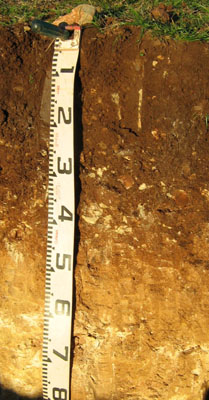 | ||
| A1 | 0 – 20 cm | Dark reddish brown (5YR3/2); heavy clay loam (subplastic); strong fine (2 – 5 mm) granular structure; few (2 – 10%) subrounded limestone pebbles (6 – 20 mm); weak consistence moist; clear change to: | |
| Subsoil | |||
| B21 | 20 – 40/50 cm | Dark reddish brown (5YR3/4); medium clay; strong fine (5 – 10 mm) polyhedral structure; common (10 – 20%) subangular limestone pebbles (20 – 60 mm); very firm consistence moist; clear and wavy change to: | |
| B22 | 40/50 -60 mm | Light brown (7.5YR6/4) mottled with strong brown (7.5YR5/6); silty clay; weak medium (10 – 20 mm) polyhedral structure; few (2 – 10%) subangular limestone pebbles (20 – 60 mm); firm consistence dry; clear change to: | |
| C | 60 – 100 mm | White (7.5YR8/1), soft limestone; few (2 – 10%) subangular limestone pebbles (20 – 60 mm); limestone becoming stronger with depth |
Key profile features
- Lack of texture contrast between the surface (A) horizon and the subsoil (B) horizon.
- Moderately shallow profile depth to limestone.
| pH | Salinity rating | Sodicity | Dispersion | Slaking | |
| Surface soil (A1 horizon) | Slightly alkaline | Very low | Non sodic | None | Slake considerably |
| Subsoil (B21 horizon) | Moderately alkaline | Very low | Non sodic | None | Slakes partially |
| Deeper subsoil (60-100 cm) | Strongly alkaline | Very low | Non sodic | None | Slakes considerably |
| Horizon | Depth cm | Field texture | pH water | pH CaCl2 | EC dS/m | Coarse sand % | Fine sand % | Silt % | Clay % | Loss on acid treat-ment1 | Field cap. % w/w | Wilt. point % w/w |
| A1 | 0-20 | CL | 7.7 | 7.2 | 0.08 | 3 | 9 | 23 | 49 | 6 | 38.5 | 22.8 |
| B21 | 20-40/45 | MC | 8.2 | 7.6 | 0.06 | 8 | 9 | 14 | 37 | 28 | 33.4 | 18.8 |
| B22 | 40-60 | ZC | 8.6 | 7.8 | 0.04 | 12 | 16 | 9 | 26 | 37 | 34.2 | 14.7 |
| C | 60-100 | Lime-stone | 8.8 | 7.8 | 0.03 | 19 | 9 | 8 | 16 | 38 | 36.3 | 10.4 |
| Depth | OrgC# | Total N | Free Fe2O3 | Exch. Al | Exchangeable cations cmol(+)/kg | Ca:Mg | ESP | ||||||
| cm | % | % | % w/w | ppm | Ca | Mg | K | Na | Total | H | CEC | ||
| 0-20 | 4.3 | 0.36 | <10 | 38 | 0.99 | 0.52 | 0.17 | 39.7 | 39.7 | 38 | <1 | ||
| 20-40/45 | 2.2 | 0.17 | <10 | 34 | 0.6 | 0.38 | 0.13 | 35.1 | 35.1 | 57 | <1 | ||
| 40-60 | 0.51 | <0.05 | <10 | 25 | 0.22 | <0.05 | 0.13 | 25.3 | 25.3 | 120 | <1 | ||
| 60-100 | 0.31 | <0.05 | <10 | 24 | 0.28 | <0.05 | 0.11 | 24.4 | 24.4 | 88 | <1 | ||
Management considerations
Whole profile
- Plant available water (PAW) here is considered to be moderate, estimated to be 90 mm. Because of the variability in the depth of soil cover within this map unit, many soils will have low to very low water-holding capacity. Effective rooting depth is limited to the depth to rock.
- The surface soil here is slightly alkaline and no response to additional lime would occur.
- The soils are low in soluble salts.
- Potassium levels are moderate and plant responses to potassium fertiliser are unlikely given the present grazing management.
- The nutrient holding capacities of the surface (A1 and B21) horizons are high (based on the sum of the exchangeable calcium, magnesium, potassium and sodium cations).
- The subsoil is well drained as there is no sharp increase in clay content at the A/B boundary.
- The subsoil horizons are non-sodic and strongly structured, which will enable plant roots to penetrate easily until they reach decomposing limestone that acts as both a physical and chemical barrier.