Wulgulmerang (Symbol: Wl)
EG40 | EG47 | EG87 | EG215
Geology
Devonian rhyolites and rhyodacites (Wellington Rhyolites, Snowy River Volcanics).
Landform
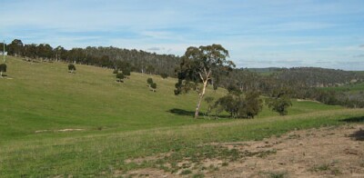
In the context of this report the Wulgulmerang map unit encompasses rolling low hills to rolling hills at an elevation range of about 300 to 1,000 m and a relief range of mostly 30 to 90 m. The slope gradients are less than 32% but are generally gentler, commonly less than 10%. The map unit may be subdivided into at least three components: gentle slopes, crests and open depressions.
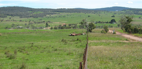
The rolling low hills of the Wulgulmerang map unit near Mt Hamilton.
Original vegetation
Montane dry woodland.
Soils
Component 1: Soils on the gentle slopes
The soils examined were generally pale in colour and strongly acidic with surface textures ranging from sandy loams to silty loams. The subsurface soils were all strongly beached, had massive to weak structure and a low water and nutrient holding capacity. Minor rock outcrops may occur on hill crests and steeper areas.
Component 2: Soils on the crests
As above, but with variable amounts of exposed rock. No sites were examined.
Component 3: Soils in the open depressions.
The depressions form only a minor component of this unit and are not described.
Land use
Most of the area defined by this map unit is cleared and used for grazing with smaller areas of remnant vegetation.
Site EG40
| Location: Gelantipy | Geo. Ref. 615700E 5876400N |
| Australian soil classification: Acidic, Regolithic, Bleached-Orthic TENOSOL | Uniform deep sandy soil |
| General landscape description: Undulating rises | |
| Geology: Devonian acid volcanics (Snowy River Volcanics) | |
| Site description: Upper slope of low hill, 4% slope, auger sample on roadside | |
| Native vegetation: Montane dry woodland | |
| Map unit: Wulgulmerang (Component 1) |
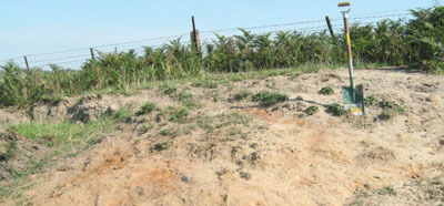
Soil exposed adjoining road near site
Soil profile morphology
| A1 | 0 – 10 cm | Weak red (2.5YR4/2); sandy loam; weak angular blocky structure; very weak consistence moist, clear change to: |
| A2 | 10 – 50 cm | Light brownish grey (10YR6/4) mottled with pale yellow (2.5Y8/4); coarse sandy loam; single grain; very weak consistence dry; few (2 – 10%) small gravel (2 – 6 mm); gradual change to: |
| A3 | 50 – 70+ cm | Yellowish brown (10YR5/6), pale yellow dry; coarse loamy sand (2.5Y7/2); massive; weak consistence dry; common (10 – 20%) subangular small gravel (2 – 6 mm) |
Key profile features
- Very sandy and no texture change throughout the profile.
| pH | Salinity rating | Sodicity | Dispersion | Slaking | |
| Surface soil (A1 horizon) | Slightly acid | Very low | Non-sodic | Minimal aggregation | Minimal aggregation |
| Subsoil (A2 horizon) | Strongly acid | Very low | Non-sodic | Minimal aggregation | Minimal aggregation |
| Deeper subsoil (50-70 cm) | Strongly acid | Very low | Non-sodic | Minimal aggregation | Minimal aggregation |
| Horizon | Depth cm | Field texture | pH water | pH CaCl2 | EC dS/m | Coarse sand % | Fine sand % | Silt % | Clay % | Field cap. % w/w | Wilt. point % w/w | PAW* water % w/w |
| A1 | 0-10 | SL | 6.2 | 5.7 | 0.07 | 38 | 31 | 18 | 9 | 23.9 | 6.0 | 17.9 |
| A2 | 10-50 | KSL | 5.0 | 4.4 | <0.05 | 33 | 36 | 22 | 8 | 18.2 | 3.6 | 14.6 |
| A3 | 50-70 | KLS | 5.0 | 4.4 | 0.05 | 38 | 31 | 22 | 10 | 17.5 | 4.4 | 13.1 |
| Depth | OrgC# | Total N | Free Fe2O3 | Exch. Al | Exchangeable cations cmol(+)/kg | Ca:Mg | ESP | ||||||
| cm | % | % | % w/w | ppm | Ca | Mg | K | Na | Total | H | CEC | ||
| 0-10 | 1.4 | 0.1 | <1 | 5.5 | 1.0 | 0.31 | 0.05 | 6.9 | 4.8 | 11.8 | 5.6 | 0 | |
| 10-50 | 83 | 0.94 | 0.26 | 0.16 | 0.06 | 1.4 | 4.9 | 6.4 | 3.7 | 1 | |||
| 50-70 | 88 | 0.81 | 0.42 | 0.18 | 0.07 | 1.5 | 3.7 | 5.2 | 2.0 | 1 | |||
Management considerations
Whole profile
- Apart from the immediate surface soil, the soil is strongly acid throughout. The calcium levels and the pH of the surface soil indicate lime has possibly been applied in the past, but further evaluation may be needed in the future.
- The plant available water content is low, estimated at 53 mm for a rooting depth of 70 cm. This figure will depend on the degree to which the roots can penetrate the massive A2 and A3 horizon, and overcome the strongly acid conditions.
- The organic matter content of the soil is very low. As the soil was sampled by auger on the road reserve, this may not reflect the conditions in the paddock.
- The low wilting point of the surface horizons indicates plants will be able to use light rains when the soil is dry. Due to the low water storage capacity of the soil, plants will suffer water stress unless further rains occur.
- The nutrient holding capacity of the soil is low (based on the sum of the exchangeable cations).
- Potassium levels are bordering on deficiency level, but no response would be expected at this stage.
- Strongly acidic subsurface horizon with moderate to high exchangeable aluminium levels may restrict growth of aluminium sensitive species such as lucerne.
- The hard setting nature of the A2 and A3 horizons, together with the strong acidity of the profile may impede root penetration.
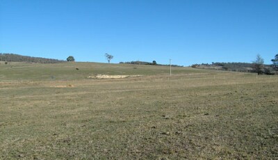
| Location: Peppermint Hill | Geo. Ref. 613400E 5883400N |
| Australian soil classification: Bleached, Eutrophic, Grey KUROSOL (gravelly) | Strongly bleached grey texture contrast soil |
| General landscape description: Rolling low hills | |
| Geology: Devonian acid volcanics (Snowy River Volcanics) | |
| Site description: Hill-slope, WNW aspect, 17% slope | |
| Native vegetation: Montane dry woodland | |
| Map unit: Wulgulmerang (Component 1) |
Soil profile morphology
| Surface soil | 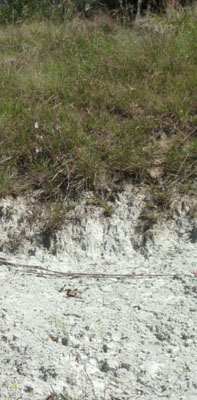 No soil profile photo provided, the road exposure opposite is near the Gelantipy Bush Nursing Centre | ||
| A1 | 0 – 10 cm | Very dark greyish brown (10YR3/2); sandy loam; weak medium polyhedral structure; weak consistence (moderately moist); common (10 – 20%) subrounded small gravel (2 – 6 mm); clear change to: | |
| A2 | 10 – 45 cm | Pale brown (10YR6/3) conspicuously bleached (10YR7/2d); silty loam with coarse sand; massive; very firm consistence dry; many (20 – 50%) subrounded small gravel, abrupt change to: | |
| Subsoil | |||
| B2 | 45 – 60 cm | Light brownish grey (10YR6/2); medium clay; strong coarse (20 – 50 mm) prismatic structure; very firm moist | |
Key profile features
| |||
Soil profile characteristics
| Horizon | Depth cm | Field texture | pH water | pH CaCl2 | EC dS/m | Coarse sand % | Fine sand % | Silt % | Clay % | Field cap. % w/w | Wilt. point % w/w | PAW* water % w/w |
| B2 | 45-60 | MC | 5.2 | 4.2 | 0.08 | 10 | 22 | 24 | 39 | 37.7 | 20.5 | 17.2 |
| Depth | OrgC# | Total N | Free Fe2O3 | Exch. Al | Exchangeable cations cmol(+)/kg | Ca:Mg | ESP | ||||||
| cm | % | % | % w/w | ppm | Ca | Mg | K | Na | Total | H | CEC | ||
| 45-60 | 410 | 2.8 | 5.2 | 0.37 | 0.46 | 8.9 | 12.0 | 20.9 | 0.6 | 2 | |||
Management considerations
- The ‘B’ horizon is strongly acid with very high levels of exchangeable aluminium (410 ppm). This indicates aluminium and manganese toxicity may occur and restrict the growth of aluminium sensitive species such as lucerne. There should be long term benefits of applying lime, preferably incorporated, on this site if the test results are representative of the paddock. A pH/aluminium test is, however, best performed from samples taken across the paddock and bulked together. Other factors need to be considered, however, before lime is recommended (eg. pasture species grown, method of application, local trial responses, soil surface structure and likely cost/benefit).
| Location: Wulgulmerang | Geo. Ref. 611800E 5898100N |
| Australian soil classification: Bleached, Magnesic, Grey KUROSOL | Bleached acidic texture contrast soil |
| General landscape description: Rolling hills | |
| Geology: Devonian acid volcanics (Snowy River Volcanics) | |
| Site description: Upper slope, ENE aspect, 10 % slope | |
| Land use: Grazing | |
| Map unit: Wulgulmerang (Component 1) |
Soil profile morphology
| Surface soil | 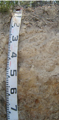 | ||
| A1 | 0 – 5 cm | Dark greyish brown (10YR4/2); loam; weak crumb structure; very weak consistence dry; clear change to: | |
| A21 | 5 – 30 cm | Pale brown (10YR6/3) conspicuously bleached (7.5YR8/2d); silty loam; massive; firm consistence dry; few (2 – 10%) subangular gravel (2 – 6 mm) fragments; gradual transition to: | |
| A22 | 30 – 60 cm | Very pale brown (10YR7/4); silty loam; massive; very firm consistence moderately moist; many (20 – 50%) subangular fine to coarse gravel (2 – 60 mm) fragments; clear change to: | |
| Subsoil | |||
| B2 | 60 – 90+ cm | Distinctly mottled pale brown (10YR6/3) and red (2.5YR5/6); medium clay; moderate to strong coarse polyhedral structure; very firm consistence (moderately moist). | |
Key Profile Features
| |||
Soil profile characteristics
| pH | Salinity rating | Sodicity | Dispersion | Slaking | |
| Surface soil (A1 horizon) | Strongly acid | Very low | Non sodic | None | Slakes partially |
| Subsoil (A21 horizon) | Strongly acid | Very low | Non sodic | None | Slakes partially |
| Deep subsoil (B2 horizon) | Strongly acid | Very low | Non sodic | None | Slakes partially |
| Horizon | Depth cm | Field texture | pH water | pH CaCl2 | EC dS/m | Coarse sand % | Fine sand % | Silt % | Clay % | Field cap. % w/w | Wilt. point % w/w | PAW* water % w/w |
| A1 | 0-5 | L | 5.2 | 4.5 | <0.05 | 31 | 36 | 20 | 9 | 22.0 | 5.6 | 16.4 |
| A21 | 5-30 | ZL | 5.0 | 4.3 | <0.05 | 28 | 32 | 28 | 11 | 19.6 | 5.5 | 14.1 |
| A22 | 30-60 | ZL | 5.0 | 4.3 | <0.05 | 34 | 23 | 26 | 17 | 19.4 | 6.8 | 12.6 |
| B2 | 60-90 | MC | 5.2 | 4.1 | <0.05 | 23 | 9 | 11 | 57 | 37.7 | 21.9 | 15.8 |
| Depth | OrgC# | Total N | Free Fe2O3 | Exch. Al | Exchangeable cations cmol(+)/kg | Ca:Mg | ESP | ||||||
| cm | % | % | % w/w | ppm | Ca | Mg | K | Na | Total | H | CEC | ||
| 0-5 | 3.5 | 0.11 | 58 | 2.0 | 0.79 | 0.42 | 0.07 | 3.3 | 9.7 | 11.0 | 2.6 | 1 | |
| 5-30 | 140 | 0.21 | 0.24 | 0.25 | <0.05 | 0.8 | 5.6 | 6.4 | 0.9 | 0 | |||
| 30-60 | 160 | 0.13 | 0.34 | 0.23 | 0.07 | 0.8 | 5.3 | 6.1 | 0.4 | 1 | |||
| 60-90 | 640 | 0.1 | 1.5 | 0.41 | 0.22 | 2.3 | 13.0 | 15.3 | 0.1 | 1 | |||
Management considerations
Whole profile
- The profile is strongly acid throughout.
- After prolonged periods of rain, the soil horizons above the subsoil clay could become water-logged.
- Plant available water capacity is considered to be low to moderate estimated at 67 mm. This is based on the laboratory data, and a rooting depth of 80 cm.
- Exchangeable aluminium levels are high, which means that the soil is not suited to aluminium-sensitive crops such as lucerne.
- The soil has moderate organic matter content, estimated at 6%.
- The low wilting point of the surface horizons indicates that plants will be able to use light rains when the soil is dry. Due to the low water storage capacity of the soil, plants will suffer water stress unless further rains occur.
- The pH is strongly acidic and a strong response to lime would be expected. Before lime is applied further tests, e.g. laboratory tests and lime test strips, are recommended to determine a likely cost/benefit. In strongly acid soils deficiencies in molybdenum and phosphorus may occur.
- The nutrient holding capacity of the soil is low (based on the sum of the exchangeable basic cations).
- Potassium levels are moderate, bordering on deficient , so no marked response to potassium fertilisers would be expected.
- The subsoil has very low inherent fertility
- As the subsoil has extremely high exchangeable aluminium content root development of aluminium-sensitive species into this zone will be restricted.
| Location: Wulgulmerang | Geo. Ref. 0613500E 5902800N |
| Australian soil classification: Bleached-Mottled, Mesotrophic, Grey KANDOSOL (strong) | Bleached acidic gradational soil |
| General landscape description: Rolling hills | |
| Geology: Devonian acid volcanics (Snowy River Volcanics) | |
| Site description: Mid-slope of a low hill, >3 % slope | |
| Land use: Grazing | |
| Native Vegetation: Montane dry woodland | |
| Map unit: Wulgulmerang (Component 1) |
Soil profile morphology
| A1 | 0 – 18 cm | Dark brown (10YR3/3); sandy loam; weak fine (2 – 5 mm) granular structure; very weak consistence moist; diffuse change to: | 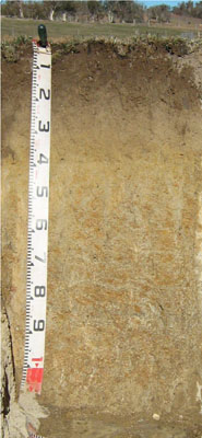 |
| A2 | 18 – 40 cm | Brown (10YR5/3) conspicuously bleached (10YR8/2d); sandy loam; massive; few (2 – 10 mm) surrounded quartz gravels (2 – 6 mm); clear change to: | |
| Subsoil | |||
| B21 | 40 -80 mm | Light grey (10YR7/2) with common medium distinct yellowish brown (10YR5/6) mottles; sandy clay; massive; common (10 – 20%) angular tabular medium (6 – 20 mm) pebbles; gradual change to: | |
| B2 | 80 – 120 cm | Very pale brown (10YR7/3) with many coarse distinct dark yellowish brown (10YR4/4) mottles; clayey sand; abundant (50 -90%) angular tabular medium (6 – 20 mm) pebbles | |
Key profile features
| |||
Soil profile characteristics
| pH | Salinity rating | Sodicity | Dispersion | Slaking | |
| Surface soil (A1 horizon) | Strongly acid | Very low | Non sodic | None | Slakes partially |
| Subsoil (B21 horizon) | Moderately acid | Very low | Non sodic | None1 | Slakes considerably |
| Deeper subsoil (80 -120 cm) | Moderately acid | Very low | Non sodic | Moderate | Slakes considerably |
| Horizon | Depth cm | Field texture | pH water | pH CaCl2 | EC dS/m | Coarse sand % | Fine sand % | Silt % | Clay % | Field cap. % w/w | Wilt. point % w/w | PAW* water % w/w |
| A1 | 0-15 | SL | 5.4 | 4.5 | <0.05 | 48 | 22 | 16 | 7 | 24.8 | 8.0 | 16.8 |
| A2 | 15-40 | SL | 5.6 | 4.4 | <0.05 | 45 | 23 | 16 | 11 | 21.3 | 7.0 | 14.3 |
| B21 | 40-80 | SC | 5.6 | 4.0 | <0.05 | 31 | 22 | 14 | 30 | 30.9 | 13.4 | 17.5 |
| B22 | 80-120 | CS | 5.6 | 4.0 | <0.05 | 59 | 13 | 11 | 13 | 21.0 | 8.7 | 12.3 |
| Depth | OrgC# | Total N | Free Fe2O3 | Exch. Al | Exchangeable cations cmol(+)/kg | Ca:Mg | ESP | ||||||
| cm | % | % | % w/w | ppm | Ca | Mg | K | Na | Total | H | CEC | ||
| 0-15 | 2 | 0.13 | 21 | 3.3 | 0.79 | 0.23 | 0.1 | 4.4 | 8.0 | 12.4 | 4.2 | 1 | |
| 15-40 | 0.43 | <0.05 | 65 | 2 | 0.85 | 0.11 | 0.18 | 3.1 | 4.0 | 7.1 | 2.4 | 3 | |
| 40-80 | <0.30 | <0.05 | 340 | 1 | 3.2 | 0.17 | 0.39 | 4.8 | 7.5 | 12.2 | 0.3 | 3 | |
| 80-120 | <0.30 | <0.05 | 400 | 0.76 | 2.7 | 0.12 | 0.56 | 4.0 | 6.3 | 10.3 | 0.3 | 5 | |
Management considerations
Whole profile
- The profile is moderately, bordering on strongly acid throughout.
- These soils are moderately well drained due to the high sand content.
- Plant available water capacity is considered to be low estimated at 60 mm based on the laboratory data and an effective root depth of 80 cm.
- Exchangeable aluminium levels are high, which mean than the soil is not suited to aluminium sensitive crops such as lucerne.
- The soil has low organic matter content.
- The low wilting point of the surface horizons indicates that plants will be able to use light rains when the soil is dry. Due to the low water storage capacity of the soil, plants will suffer water stress unless further rains occur.
- The nutrient holding capacity of the soil is low (based on the sum of the exchangeable basic cations).
- Potassium levels are very low and a strong response to potassium fertilisers would be expected.
- The subsoil has very low inherent fertility.
- As the subsoil has extremely high exchangeable aluminium content, root development of aluminium sensitive species into this zone will be restricted.