Victorian Resources Online (archived)
Seacombe (Symbol: Sm)
Profile No. 755 (Nicholson, 1978)
Geology
Pleistocene and recent sands.
Landform
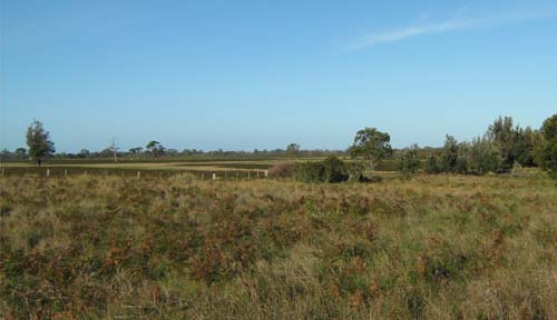
Dunefield. This landform has a level to low relief and comprises longitudinal and parabolic dunes and swales. Most of this map unit is higher than 5 m above sea level.
| Previous maps and reports This map unit was mapped by Aldrick et al. (1992) into a number of land systems, including Seacombe, Barrier, Rotamah, Tyers and Wolaston. Nicholson (1978) mapped the area into a number of land systems including Seacombe, Wulla Wullock, Banksia and Colquhoun. In this report the Secombe map unit includes the coastal dunes above 5 m. Soils All of the soils are comprised mainly of sand. These sands may have contained shell fragments and carbonates, but now the soils are leached, infertile and acidic, particularly in the surface soil. Native Vegetation Sand heath land with areas of damp sands herb-rich woodland. Land use Some areas east of Lake Wellington are cleared but most remains uncleared and is National Park or Coastal Park. Some small areas are residential mainly Loch Sport, Banksia Peninsula and parts of Raymond Island. | 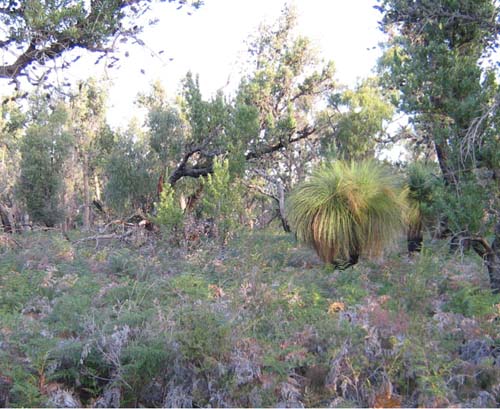 |
Profile No. 755 (Nicholson, 1978)
| Location: Not specified | |
| Australian Soil Classification: Melacic, Humosequic, Aeric PODOSOL | Uniform textured sand soil |
| General landscape description: Dunefield | |
| Geology: Pleistocene aeolian sand | |
| Site description: Not specified | |
| Land use: Not specified | |
| Native vegetation: Not specified | |
| Map unit: Seacombe |
Soil profile morphology
Surface soil
| A0 | 0 - 10 cm | Loamy coarse sand | 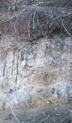 Profile similar to that described here |
| A1 | 4 - 10 cm | Loamy coarse sand | |
| A1 | 10 – 20 cm | Loamy coarse sand | |
| A2 | 20 – 30 cm | Coarse sand | |
| A2 | 30 -50 cm | Coarse sand | |
| A/B | 60 – 70 cm | Coarse sand | |
| Bhs | 70 – 76 cm | Coarse sand, high in organic carbon (coffee rock) | |
| C | 76 – 90 cm | Yellow brown coarse sand |
Key profile features
- Sand textures throughout the profile.
- The laboratory results show the soil to 20 cm is high in organic matter, which would result in dark colours as shown in this photo.
- The laboratory results show the soil is very strongly acid throughout.
| Horizon | Depth cm | Field texture | pH water | EC dS/m | Gravel % | Coarse sand % | Fine sand % | Silt % | Clay % | Field cap. % w/w | Wilt. point % w/w | PAW* water % w/w |
| A0 | 0-4 | KS (loamy) | 3.9 | 0.06 | 0 | 59 | 23 | 3 | 3 | |||
| A1 | 4-10 | KS (loamy) | 4.0 | 0.05 | 0 | |||||||
| A1 | 12-20 | KS (loamy) | 4.1 | 0.04 | 0 | 55 | 37 | 2 | 2 | |||
| A2 | 20-30 | KS | 4.2 | 0.03 | 0 | |||||||
| A2 | 30-50 | KS | 4.5 | 0.01 | 0 | 52 | 44 | 2 | 2 | |||
| A/B | 60-76 | KS | 4.6 | 0 | 50 | 46 | 2 | 2 | ||||
| B | 76-90 | KS | 4.6 | .02 | 0 | 47 | 42 | 6 | 6 | |||
| B | 76-90 | KS | 5.1 | 0.02 | 0 | 52 | 41 | 3 | 3 |
| Depth | Org C | Total N | Free Fe2O3 | Exch. Al | Exchangeable cations cmol(+)/kg | Ca:Mg | ESP | ||||||
| cm | % | % | % w/w | ppm | Ca | Mg | K | Na | Total | H | CEC | ||
| 0-4 | 7.7 | 0.16 | 0.1 | 0.3 | 0.1 | 0.1 | 22.4 | 23.4 | |||||
| 4-10 | 6.7 | 0.17 | |||||||||||
| 12-20 | 2.8 | 0.08 | <0.1 | 0.5 | 0.1 | 0.1 | 14.1 | 14.8 | |||||
| 20-30 | 1.4 | 0.04 | |||||||||||
| 30-50 | 0.1 | <0.1 | 0.1 | 0.1 | <0.1 | 1.8 | 2.0 | ||||||
| 60-76 | <0.1 | <0.1 | 0.1 | <0.1 | 0.6 | 0.7 | |||||||
| 76-90 | 1.6 | 1.4 | 0.1 | 0.1 | 0.1 | 0.1 | 21.1 | 21.5 | |||||
| 76-90 | 0.3 | <0.1 | 0.1 | 0.1 | 0.2 | 11.0 | 11.6 | ||||||
Management considerations
Whole profile
- Plant available water capacity (PAW) would moderate due to the high organic matter in the surface 20 cm.
- A major advantage of these soils is they usually drain very well and can be worked throughout the year.
- The sandy surface soil will be prone to wind erosion if plant cover is removed and blow-outs can occur.
- The soil is extremely acid, low in calcium and magnesium, and responses to dolomitic lime would be expected. Such strongly leached soils are also likely to be naturally deficient in nitrogen, phosphorus, sulphur and potassium.
- Nitrate and sulphate are readily soluble and easily removed by leaching. More regular but smaller applications of fertiliser will assist in reducing loss of nutrients through leaching. Nutrients lost through leaching may influence catchment water quality .
- Deficiencies of the trace element molybdenum (Mo) are likely to occur in acid sandy soils (soil adsorption of Mo increases as pH decreases, leading to reduced availability to plants). Lime application on acid soils will also make molybdenum more available to plants.
- The trace element boron (B) leaches rapidly through acid sandy soils and deficiencies are likely to occur.
- The ‘coffee rock’ layer may restrict the downward movement of plant roots and water. In some situations, the temporary build up of water on top of this less permeable layer may be beneficial for deeper rooted plants as it prevents deep drainage of water away from plant roots.