Victorian Resources Online (archived)
Tambo (Symbol: Tb)
EG261 | EG262 | EG263 | EG264 | EG265
Geology
Ordovician sediments.
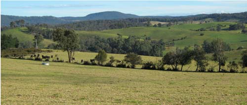
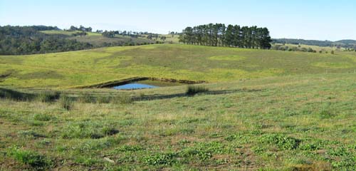
Landform
Rolling to steep low hills. Elevation range 40 – 540 m with local relief generally 30 – 90 m and slope gradients up to 32%, but typically 8 - 20%.
The Tambo map unit may be subdivided into three components: upper slopes and broad rounded crests, mid-slopes, lower slopes and open depressions.
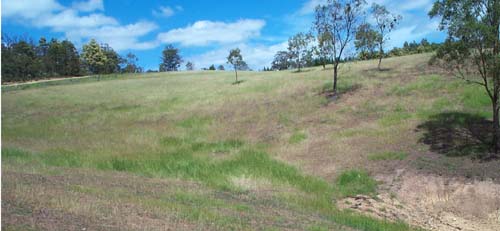
| Original vegetation Shrubby dry forest. Soils Component 1: Soils on crests and upper slopes Rock occurs in these soils generally within 1 m. The soils appear to be mostly texture contrast soils with some gradational soils on the crest and upper-most slopes. The surface soils are generally dark brown strongly acidic loams to fine sandy loams abruptly overlying brown to reddish brown acidic medium clays. Decomposing Ordovician sediments, generally mudstone, occurs before 1 m. Gradational soils appear to occur when the depth to rock is less than 0.5 m. (See Wiseleigh pit 1, Bruthen and Clifton Creek.). Component 2: Soils on mid-slopes Rock occurs in these soils around 1 m or deeper. The soils are also texture contrast soils, with the surface soils being strongly acidic dark brown loams and overly brown to reddish brown acidic medium clays. (See Wiseleigh pit 2.). Component 3: Soil on lower slopes and open depressions These soils are mostly formed on colluvium and locally derived alluvium eroded from up-slope and redeposited. The soils are likely to be quite variable, but the surface soils are likely to be dark greyish brown acidic loams. (See Wiseleigh pit 3.) These soils are likely to be sodic and dispersive with depth with the risk of gully and tunnel erosion developing. Land use Much of the area defined by this unit is uncleared but there are substantial areas cleared and used for grazing. | 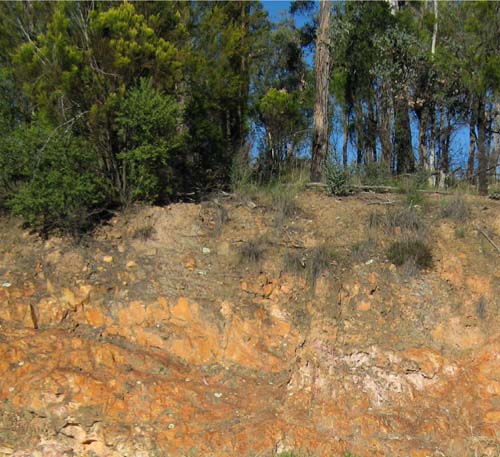 Shallow soils on Ordovician sediments in road cutting near Clifton Creek |
Site EG261
| Location: Bruthen | Geo. Ref.: 575500E 5825000N |
| Australian Soil Classification: Melacic, Eutrophic, Brown DERMOSOL | Brown gradational soil |
| General landscape description: Rolling to steep low hills | |
| Geology: Ordovician sediments | |
| Site description: Upper slope | |
| Land use: Grazing on annual pasture | |
| Native vegetation: Valley dry forest | |
| Map unit: Tambo (Component 1) |
Soil profile morphology
| Surface soil | 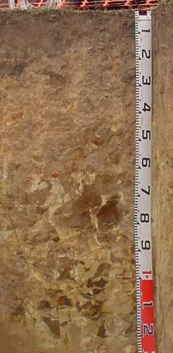 | ||
| A11 | 0 – 12 cm | Dark yellowish brown; fine sandy clay loam; few (10%) small angular pebbles (<20 mm); clear wavy change to: | |
| A12 | 12 – 35 cm | Yellowish brown; fine sandy clay loam (heavy); common (10-20%) angular pebbles (<60 mm) increasing with depth; gradual change to: | |
| A13 | 35 – 60 cm | Light brown; fine sandy clay loam (heavy); many (20-50%) angular pebbles and cobbles (<200 mm) increasing in size and amounts with depth; passing to: | |
| R | 60+ cm | Weak rock becoming stronger with depth |
Key profile features
- Uniform textures to at least 60 cm.
| pH | Sodicity | Slaking | Dispersion Dry | Dispersion Remoulded | |
| Surface soil (A11 horizon) | Strongly acid | Non-sodic | Water stable | Nil (2 hours), Nil (20 hours) | Nil (2 hours), Nil (20 hours) |
| Subsurface (A12 horizon) | Strongly acid | Non-sodic | Partial | Nil (2 hours), Nil (20 hours) | Slight (2 hours), Moderate (20 hours) |
| Deeper subsoil (35 – 60 cm) | Strongly acid | Non-sodic | Partial | Nil (2 hours), Nil (20 hours) | Moderate (2 hours), Moderate (20 hours) |
| Horizon | Depth cm | Field texture | pH water | pH CaCl2 | EC dS/m | Coarse sand % | Fine sand % | Silt % | Clay % | Field cap. % w/w | Wilt. point % w/w | PAW* water % w/w |
| A11 | 0-12 | FSL | 5.4 | 4.7 | 0.07 | 16 | 30 | 26 | 17 | 37.6 | 12.1 | 25.5 |
| A12 | 12-35 | FSCL | 5.2 | 4.4 | <0.05 | 15 | 32 | 31 | 18 | 27.1 | 8.6 | 18.5 |
| A13 | 35-60 | FSCL | 5.3 | 4.4 | <0.05 | 17 | 33 | 28 | 21 | 22.1 | 8.3 | 13.8 |
| Depth | OrgC# | Total N | Free Fe2O3 | Exch. Al | Exchangeable cations cmol(+)/kg | Ca:Mg | ESP | ||||||
| cm | % | % | % w/w | ppm | Ca | Mg | K | Na | Total | H | CEC | ||
| 0-12 | 5.7 | 0.35 | 71 | 7.1 | 1.8 | 0.4 | <0.1 | 9.4 | 17 | 26.4 | 4 | ||
| 12-35 | 200 | 1.4 | 1.3 | 0.3 | <0.1 | 3.1 | 13 | 16.1 | 1.1 | ||||
| 35-60 | 190 | 0.9 | 1.8 | 0.2 | <0.1 | 3 | 9.1 | 12.1 | 0.5 | ||||
Management considerations
Whole profile
- The brown colours throughout and lack of texture contrast indicate the profile is well drained internally.
- The soil texture is almost uniform throughout.
- The soil has a high organic matter content conferring good structural stability.
- The nutrient holding capacity of the soil is moderate (based on the sum of exchangeable cations).
- The potassium levels are marginal but the soil is unlikely to show a response to potassium fertilisers at this stage.
- The presence of increasing amounts of rock in the subsoil is likely to restrict root development.
| Location: Clifton Creek | Geo. Ref.: 556640 5827970N |
| Australian Soil Classification: Sodic, Dystrophic, Yellow CHROMOSOL | Yellow sodic texture contrast soil (shallow) |
| General landscape description: Undulating to rolling low hills | |
| Geology: Ordovician sediments | |
| Site description: Mid-slope, north aspect, 10 % slope | |
| Land use: Grazing | |
| Native vegetation: Shrubby dry forest | |
| Map unit: Tambo (Component 2) |
Soil profile morphology
| Surface soil | 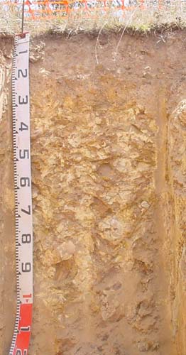 | ||
| A1 | 0 – 5 cm | Dark brown (10YR3/2); loam; weak fine subangular blocky structure; firm dry; abrupt change to: | |
| Subsoil | |||
| B21 | 5 – 20 cm | Brown (7.5YR4/2), light brown (7.5YR6/3) dry; medium clay (subplastic); moderate coarse prismatic structure; firm dry; few (<10%) angular medium pebbles (<20 mm); clear change to: | |
| B22* | 20 – 30 cm | Brown (7.5YR4/2), few coarse reddish yellow (7.5YR6/6) mottles; light clay; moderate coarse prismatic structure; common (10-20%) angular stones (200-600 mm); clear change to: | |
| C | 30 -70 cm | Yellowish brown (10YR5/4); light clay; massive; abundant (>90%) angular soft rock. | |
| *This horizon is discontinuous | |||
Key profile features
- Shallow depth of surface soil.
- Marked increase in soil texture between the A1 and B21 horizon.
- Shallow depth to soft decomposing rock.
| pH | Sodicity | Slaking | Dispersion (Dry) | Dispersion (Remoulded) | |
| Surface soil | Strongly acid | Non-sodic | Water stable | Nil (2 hours), Nil (20 hours) | Slight (2 hours), Slight (20 hours) |
| Subsoil (B22 horizon) | Moderately acid | Sodic | Water stable | Nil (2 hours), Slight (20 hours) | Moderate (2 hours), Moderate (20 hours) |
| Deep subsoil (C horizon) | Slightly alkaline | Non-sodic | Partial | Moderate (2 hours), Moderate (20 hours) | Strong (2 hours), Strong (20 hours) |
| Horizon | Depth cm | Field texture | pH water | pH CaCl2 | EC dS/m | Coarse sand % | Fine sand % | Silt % | Clay % | Field cap. % w/w | Wilt. point % w/w | PAW* water % w/w |
| 0-5 | 0-5 | L | 5.1 | 4.4 | 5.1 | 21 | 29 | 20 | 14 | 36.4 | 17.4 | 19 |
| 5-20 | 5-20 | MC | 5.7 | 4.7 | 5.7 | 18 | 28 | 7 | 41 | 26.9 | 10.3 | 16.6 |
| 20-30 | 20-30 | LC | 6.7 | 5.3 | 6.7 | 17 | 26 | 28 | 25 | 24.1 | 10.8 | 13.8 |
| 30-70 | 30-70 | LC | 7.6 | 6.4 | 7.6 | 19 | 18 | 38 | 23 | 21 | 10.3 | 10.7 |
| Depth | OrgC# | Total N | Free Fe2O3 | Exch. Al | Exchangeable cations cmol(+)/kg | Ca:Mg | ESP | ||||||
| cm | % | % | % w/w | ppm | Ca | Mg | K | Na | Total | H | CEC | ||
| 0-5 | 8.3 | 0.6 | 140 | 3.2 | 2.1 | 0.3 | 0.2 | 5.8 | 21 | 26.8 | 1.6 | <0.1 | |
| 5-20 | 2.3 | 0.11 | 100 | 0.3 | 1.2 | <0.1 | 0.4 | 2 | 12 | 14.0 | 0.3 | 3 | |
| 20-30 | 13 | 0.1 | 2.6 | 0.1 | 0.6 | 3.4 | 6.1 | 9.5 | <0.1 | 6 | |||
| 30-70 | <5 | <0.1 | 3.4 | <0.1 | 0.3 | 3.9 | 1.7 | 5.6 | <0.1 | 5 | |||
Management considerations
Whole profile
- On the assumption the roots can extract the water in the top 25 cm of the soil, the plant available water capacity is estimated at 38 mm. The high amounts of organic matter in this surface soil have added to the soil’s ability to retain water.
- The surface soil is strongly acidic but in the subsoil it is moderately acidic. Lime is unlikely to show any economic benefit.
- Potassium is deficient and a response to potassium fertiliser is likely. This would particularly apply if the pasture was removed and baled.
- The nutrient holding capacity of the soil is low (based on the sum of the basic cations) and the depth of surface soil is shallow.
- Based on the sum of the basic cations, the subsoil has a very low nutrient holding capacity.
- The subsoil is non-sodic and only slightly dispersive. Given the presence of increasing amounts of rock down the profile, gully and tunnel erosion is unlikely.
Wiseleigh Pits (EG263, EG264, EG265)
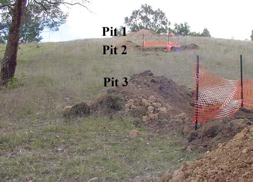
Sequence of soil pits examined at Wiseleigh
Site EG263
| Location: Wiseleigh | Geo. Ref.: 570600E 5826400N |
| Australian Soil Classification: Melacic, Dystrophic, Brown KUROSOL | Brown texture contrast soil |
| General landscape description: Rolling low hills | |
| Geology: Ordovician sediments | |
| Site description: Pit 1: Upper south slope, 15% slope | |
| Land use: Grazing | |
| Native vegetation: Grassy woodland | |
| Map unit: Tambo (Component 1) |
Soil profile morphology
| Surface soil | 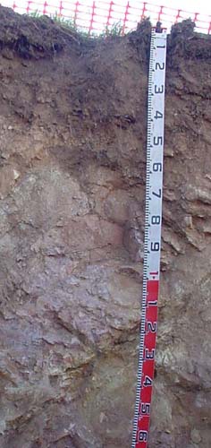 | ||
| A11 | 0 – 5 cm | Black (10YR2/1); loam; strong fine granular structure; weak consistence moderately moist; wavy change to: | |
| A12 | 5 – 30 cm | Dark brown (7.5YR3/2); loam; moderate fine subangular blocky structure; firm consistence moderately moist; few (2-10 %) angular pebbles (20-60 mm) of parent rock; wavy change to: | |
| Subsoil | |||
| B2 | 30 – 50 cm | Dark reddish brown (5YR3/2); medium clay; weak fine polyhedral structure; firm consistence moderately moist; common (10-20%) angular pebbles (20-60 mm) of parent rock; wavy change to: | |
| C | 50 – 70 cm | Brown (7.5YR4/3); sandy loam; massive; firm consistence moderately moist; abundant (50-90%) angular pebbles and cobbles (<200 mm) mm) of parent rock; wavy change to: | |
| R | 100 cm+ | Weak rock becoming stronger with depth |
Key profile features
- Texture contrast between the surface (A) horizons and the subsoil (B horizons).
- Very high organic matter in the surface soil, which enhances nutrient and water-holding capacity.
| pH | Sodicity | Slaking | Dispersion (Dry) | Dispersion (Remoulded) | |
| Surface soil (A11) | Very strongly acid | Non-sodic | Minimal aggregation | Minimal aggregation | Minimal aggregation |
| Subsoil (B2 horizon) | Very strongly acid | Non-sodic | Water stable | Nil (2 hours), Nil (20 hours) | Nil (2 hours), Nil (20 hours) |
| Deep subsoil (C horizon) | Strongly acid | Non-sodic | Water stable | Nil (2 hours), Nil (20 hours) | Nil (2 hours), Nil (20 hours) |
| Horizon | Depth cm | Field texture | pH water | pH CaCl2 | EC dS/m | Coarse sand % | Fine sand % | Silt % | Clay % | Field cap. % w/w | Wilt. point % w/w | PAW* water % w/w |
| A11 | 0-5 | L | 4.8 | 4.2 | 0.13 | 27 | 27 | 7 | 23 | 51.7 | 27.4 | 24.3 |
| A12 | 5-30 | L | 4.8 | 4.2 | 0.05 | 23 | 24 | 23 | 21 | 41.6 | 13.2 | 28.4 |
| B2 | 30-50 | MC | 5 | 4.4 | <0.05 | 29 | 23 | 2 | 44 | 34.1 | 10.4 | 23.7 |
| C | 50-70 | SL | 5.1 | 4.7 | <0.05 | 40 | 18 | 26 | 16 | 21.7 | 7.1 | 14.6 |
| Depth | OrgC# | Total N | Free Fe2O3 | Exch. Al | Exchangeable cations cmol (+) /kg | Ca:Mg | ESP | ||||||
| cm | % | % | % w/w | ppm | Ca | Mg | K | Na | Total | H | CEC | ||
| 0-5 | 14 | 0.77 | 220 | 5.5 | 2.6 | 0.7 | <0.1 | 8.8 | 21 | 29.8 | 2.1 | <1 | |
| 5-30 | 4.6 | 0.18 | 500 | 0.5 | 0.4 | 0.2 | <0.1 | 1.1 | 22 | 23.1 | 1.3 | <1 | |
| 30-50 | 2.2 | 0.1 | 240 | <0.1 | 0.1 | 0.1 | <0.1 | 0.2 | 15 | 15.2 | <1 | ||
| 50-70 | 92 | <0.1 | <0.1 | <0.1 | <0.1 | 5.3 | 5.3 | <1 | |||||
Management considerations
Whole profile
- On the assumption the roots can extract the water in the top 50 cm of the soil, the plant available water capacity is estimated at 56 mm. The high amounts of organic matter in this surface soil have added to the soil’s ability to retain water.
- The surface soil is very strongly acidic and the high levels of exchangeable aluminium are likely to restrict the growth of aluminium sensitive species. A response to lime would be expected, but before it is applied, test strips should be used to evaluate the cost/benefit.
- The nutrient holding capacity of the immediate surface soil is moderate (based on the sum of the basic cations) largely due to its high organic matter content. The immediate subsurface soil has an extremely low nutrient holding capacity.
- Based on the sum of the basic cations, the subsoil has an extremely low nutrient holding capacity.
- The subsoil is non-sodic and not dispersive. Given the presence of increasing amounts of rock down the profile, gully and tunnel erosion in this particular soil is unlikely.
| Location: Wiseleigh | Geo. Ref.: 570600E 5826400N |
| Australian Soil Classification: Melacic, Magnesic (and Dystrophic), Brown CHROMOSOL | Brown texture contrast soil |
| General landscape description: Gently undulating plain | |
| Geology: Ordovician sediments | |
| Site description: Pit 2: Mid south slope, 17% slope | |
| Land use: Grazing | |
| Native vegetation: Grassy woodland | |
| Map unit: Tambo (Component 2) |
Soil profile morphology
| Surface soil | 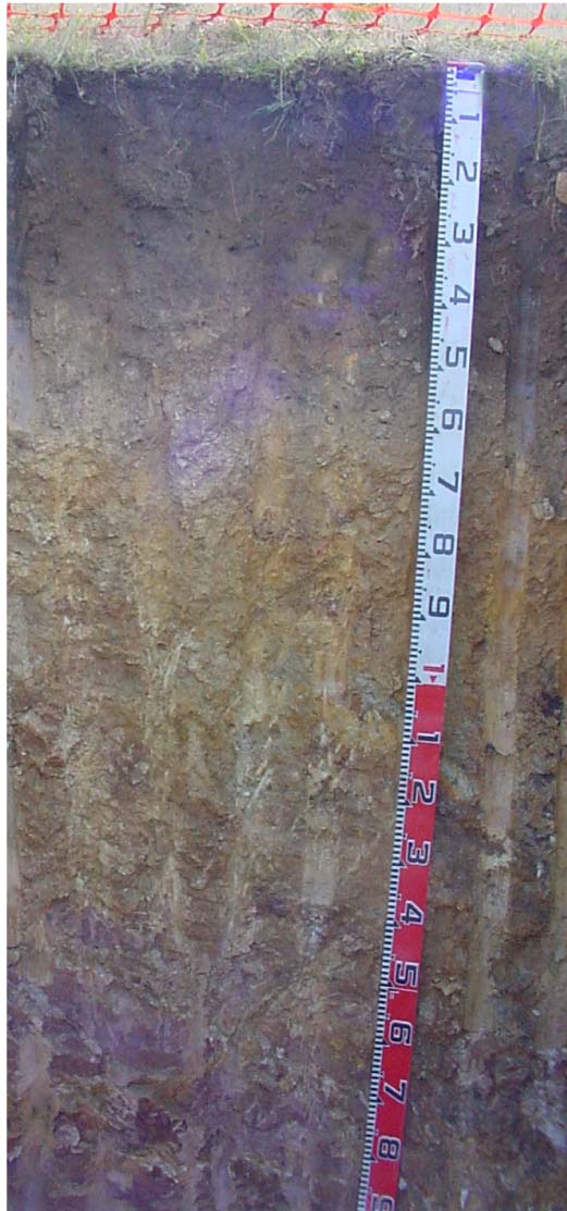 | ||
| A11 | 0 – 8 cm | Very dark grey (7.5YR3/1); loam; strong fine granular structure; firm consistence dry; abrupt change to: | |
| A12 | 8 – 35 cm | Very dark grey (7.5YR3/1); clay loam; weak fine angular blocky structure; firm consistence dry ; clear change to: | |
| Subsoil | |||
| B21 | 35 – 50 cm | Brown (7.5YR5/4) medium clay; moderate coarse (50 – 100 mm) prismatic structure; firm consistence dry; few (2 – 10%) angular pebbles (< 60 mm); gradual change to: | |
| B22 | 50 – 70 cm | Light brown (7.5YR6/4); light clay; moderate coarse (50 – 100 mm) prismatic structure; very firm consistence dry; few (2 – 10%) angular pebbles (< 60 mm); gradual change to: | |
| C | 70 – 100 cm | Mottled yellow (10YR7/6) and reddish yellow (5YR6/6); light clay; strong medium (10 – 20 mm) polyhedral structure; very firm consistence dry; diffuse change to: | |
| R | 100 cm+ | Weak decomposing rock |
Key profile features
- Texture contrast between the surface (A) horizons and the subsoil (B horizons).
- Very high organic matter in the surface soil, which enhances nutrient and water-holding capacity.
| pH | Sodicity | Slaking | Dispersion (Dry) | Dispersion (Remoulded) | |
| Surface soil (A11) | Very strongly acid | Non-sodic | Minimal aggregation | Minimal aggregation | Minimal aggregation |
| Subsoil (B21 horizon) | Moderately acid | Non-sodic | Partial | Nil (2 hours), Nil (20 hours) | Nil (2 hours), Slight (20 hours) |
| Deep subsoil (C horizon) | Slightly acid | Sodic | Partial | Slight (2 hours), Moderate (20 hours) | Strong (2 hours), Complete (20 hours) |
| Horizon | Depth cm | Field texture | pH water | pH CaCl2 | EC dS/m | Coarse sand % | Fine sand % | Silt % | Clay % | Field cap. % w/w | Wilt. point % w/w | PAW* water % w/w |
| A11 | 0-8 | L | 4.9 | 4.2 | 0.12 | 24 | 23 | 19 | 19 | 53.1 | 30 | 23.1 |
| A12 | 8-35 | CL | 5.0 | 4.3 | <0.05 | 17 | 24 | 23 | 28 | 53.0 | 15.2 | 37.8 |
| B21 | 35-50 | MC | 5.8 | 4.7 | <0.05 | 18 | 22 | 13 | 44 | 34.4 | 14.1 | 20.3 |
| B22 | 50-70 | LC | 5.8 | 4.7 | <0.05 | 22 | 21 | 27 | 28 | 29.3 | 12.4 | 16.9 |
| C | 70-100 | LC | 6 | 4.6 | <0.05 | 8 | 16 | 46 | 29 | 35.5 | 14.7 | 20.8 |
| Depth | OrgC# | Total N | Free Fe2O3 | Exch. Al | Exchangeable cations cmol(+)/kg | Ca:Mg | ESP | ||||||
| cm | % | % | % w/w | ppm | Ca | Mg | K | Na | Total | H | CEC | ||
| 0-8 | 11 | 0.59 | 360 | 3.4 | 3.2 | 0.9 | 0.1 | 7.6 | 18 | 25.6 | 1.1 | <1 | |
| 8-35 | 5.3 | 0.22 | 460 | 0.2 | 0.7 | 0.2 | 0.1 | 1.2 | 20 | 21.2 | 0.3 | <1 | |
| 35-50 | 140 | <0.1 | 0.7 | 0.2 | 0.1 | 1.1 | 13 | 14.1 | <0.1 | <1 | |||
| 50-70 | 82 | <0.1 | 0.7 | 0.1 | <0.1 | 1 | 6.1 | 7.1 | <0.1 | <1 | |||
| 70-100 | 55 | <0.1 | 1.3 | 0.2 | 0.2 | 1.8 | 4.2 | 6.0 | <0.1 | 11 | |||
Management considerations
Whole profile
- Based on a plant root depth of 50 cm, the plant available water capacity is about 62 mm.
- Texture contrast between the surface (A horizons) and the subsoil (B horizon).
- The surface (A11) horizon has a particularly high organic matter content which has greatly added to the nutrient holding and water holding capacity of the soil. By contrast the subsurface soil (A12) horizon has a very low nutrient holding capacity.
- The surface soil is very strongly acidic and the very high levels of exchangeable aluminium are likely to restrict the growth of aluminium sensitive species. A response to lime would be expected, but before it is applied, test strips should be used to evaluate the cost/benefit.
- All of these horizons have a very low nutrient holding capacity (based on the sum of the calcium, magnesium, potassium and sodium cations).
- The deep subsoil (C horizon) is sodic and shows moderate dispersion after 20 hours of wetting. Such a soil would be prone to tunnel and gully erosion.
| Location: Wiseleigh | Geo. Ref.: 570600E 5826300N |
| Australian Soil Classification: Sodic, Magnesic (and Dystrophic), Brown DERMOSOL | Brown gradational soil |
| General landscape description: Gently undulating plain | |
| Geology: Colluvium derived from further up-slope | |
| Site description: Pit 3: Lower south-south east slope, 12% | |
| Land use: Grazing | |
| Native vegetation: Shrubby dry forest | |
| Map unit: Tambo (Component 3) |
Soil profile morphology
| Surface soil | 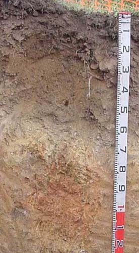 | ||
| A11 | 0 – 10 cm | Very dark grey (7.5YR3/1); loam; moderate fine subangular blocky structure; firm consistence dry; clear change to: | |
| A12 | 10 – 55 cm | Dark brown (7.5YR3/2); fine sandy light clay; moderate fine subangular blocky structure; firm consistence dry; clear change to: | |
| A2 | 55 – 65 cm | Light yellowish brown (10YR6/4); fine sandy clay loam; massive; very firm consistence dry; few (2-10%) angular quartz gravel (6-20 mm); clear change to: | |
| Subsoil | |||
| B2 | 65 – 85 cm | Yellowish red (5YR4/6); fine sandy clay loam; moderate coarse (50 – 100 mm) angular blocky structure; strong consistence dry; few (2-10%) angular quartz gravel (6-20 mm); clear change to: | |
| C1 | 85 – 120 cm | Yellowish red (5YR4/6); fine sandy light clay; weak fine angular blocky structure; very firm consistence dry; few (2-10%) angular quartz gravel (6-20 mm); gradual change to: | |
| C2 | 1.2 – 1.9 m | Pale brown (10YR6/3); light clay; strong medium (10 – 20 mm) polyhedral structure; very firm consistence dry; diffuse change to: | |
| C3 | 1.9 – 2.4 m | Dark reddish grey (5YR4/2); light medium clay; few (2-10%) angular quartz gravel (6-60 mm). |
Key profile features
- Deep dark coloured surface horizons indicate a high organic matter content and high water retention properties.
- It is likely much of the surface soil has been derived from further upslope post-clearing.
Soil profile characteristics
| pH | Sodicity | Slaking | Dispersion (Dry) | Dispersion (Remoulded) | |
| Surface soil (A11) | Very strongly acid | Non-sodic | Minimal aggregation | Minimal aggregation | Minimal aggregation |
| Subsoil (B2 horizon) | Slightly acid | Non-sodic | Considerable | Moderate (2 hours), Moderate (20 hours) | Strong (2 hours), Strong (20 hours) |
| Deep subsoil (C2 horizon) | Slightly alkaline | Sodic | Considerable | Strong (2 hours), Strong (20 hours) | Strong (2 hours), Strong (20 hours) |
| Horizon | Depth cm | Field texture | pH water | pH CaCl2 | EC dS/m | Coarse sand % | Fine sand % | Silt % | Clay % | Field cap. % w/w | Wilt. point % w/w | PAW* water % w/w |
| A11 | 0-10 | L | 5.1 | 4.4 | 0.08 | 23 | 24 | 21 | 18 | 44.7 | 23.2 | 21.5 |
| A12 | 10-55 | FSLC | 5.4 | 4.5 | <0.05 | 18 | 28 | 7 | 39 | 42.9 | 12.5 | 3.4 |
| A2 | 55-65 | FSCL | 6 | 4.8 | <0.05 | 25 | 34 | 21 | 18 | 21 | 8.1 | 12.9 |
| B2 | 65-85 | FSCL | 6.2 | 4.9 | <0.05 | 24 | 30 | 21 | 23 | 20.3 | 9.2 | 11.1 |
| C1 | 85-120 | FSLC | 6.6 | 5.1 | 0.05 | 21 | 27 | 19 | 33 | 25.9 | 11.5 | 14.4 |
| C2 | 120-190 | LC | 7.7 | 6.1 | 0.06 | 23 | 29 | 18 | 30 | 22.8 | 9.6 | 13.2 |
| C3 | 190-240 | LMC | 8 | 6.8 | 0.2 | 18 | 21 | 14 | 45 | 30.1 | 15.4 | 14.7 |
| Depth | OrgC# | Total N | Free Fe2O3 | Exch. Al | Exchangeable cations cmol(+)/kg | Ca:Mg | ESP | ||||||
| cm | % | % | % w/w | ppm | Ca | Mg | K | Na | Total | H | CEC | ||
| 0-10 | 9.2 | 0.54 | 26 | 3.6 | 3.2 | 0.1 | 0.5 | 7.4 | 21 | 28.4 | 1.1 | 2 | |
| 10-55 | 3.5 | 0.16 | 230 | 0.6 | 0.9 | 0.3 | 0.1 | 1.9 | 21 | 22.9 | 0.7 | <1 | |
| 55-65 | 63 | <0.1 | 0.9 | <0.1 | 0.1 | 1 | 6 | 7 | <0.1 | 1 | |||
| 65-85 | 36 | <0.1 | 1.9 | <0.1 | 0.3 | 2.2 | 4.6 | 6.8 | <0.1 | 4 | |||
| 85-120 | 210 | <0.1 | 2.3 | 0.4 | 0.2 | 2.9 | 3.5 | 6.4 | <0.1 | 3 | |||
| 120-190 | <5 | <0.1 | 2.9 | <0.1 | 0.7 | 3.6 | 2.1 | 5.7 | <0.1 | 12 | |||
| 190-240 | 0.3 | 4.9 | 0.2 | 1.9 | 6.8 | 3.4 | 10.2 | <0.1 | 19 | ||||
Management considerations
Whole profile
- On the assumption the roots can extract the water in the top 65 cm of the soil, the plant available water capacity is estimated at 68 mm. The high amounts of organic matter in this surface soil have added to the soil’s ability to retain water.
- The surface soil is very strongly acidic and the high levels of exchangeable aluminium occurring in the subsurface soil are likely to restrict the growth of aluminium sensitive species. A response to lime may be expected, but before it is applied, test strips should be used to evaluate the cost/benefit.
- Potassium is deficient and a response to potassium fertiliser is likely. This would particularly apply if the pasture was removed and baled.
- The nutrient holding capacity of the immediate surface soil is low to moderate (based on the sum of the basic cations) largely due to its high organic matter content. The immediate subsurface soil has an extremely low nutrient holding capacity.
- Based on the sum of the basic cations, the subsoil has an extremely low nutrient holding capacity.
- The deep subsoils are sodic and strongly dispersive. If the soil becomes saturated there is the risk of deep tunnels and subsequent gully erosion.