Beloka (Symbol: Bk)
EG203 | EG105
Geology
Mainly colluvium and alluvium derived from Palaeozoic sediments.
Landform
Enclosed low hills comprising undulating rises.
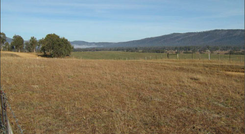
Undulating rises typical of the Beloka map unit. The timbered steep hills in the background were formed by the Livingston fault.
Original vegetation
Montane riparian woodland.
Soils
All of the soils are on colluvium derived from the Palaeozoic sediments which are higher in the landscape. Over time, material has been eroded from these sediments and redeposited forming both alluvial and colluvial deposits. The surface soils are generally dark brown silty loams and clay loams which become redder and more clayey down the soil profile. Two sites have been described, one from a soil pit (EG 203), the other from a road exposure (EG 105). Soil analyses were carried out on soils from the soil pit.
Land use
All of the area is cleared and used for grazing.
| Location: Beloka | Geo. Ref. 0580268E 5928999N |
| Australian soil classification: Acidic, Mesotrophic, Red DERMOSOL | A red gradational soil |
| General landscape description: Undulating low hills | |
| Geology: Colluvium and alluvium derived from Palaeozoic sediments | |
| Site description: Simple mid-slope, 3% slope to north | |
| Land use: Grazing on annual pasture | |
| Native vegetation: Montane riparian woodland | |
| Mapping unit: Beloka |
Soil profile morphology
| Surface soil | 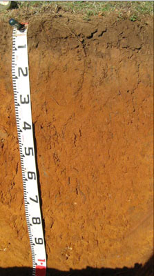 | ||
| A11 | 0 – 12 cm | Dark brown (7.5YR4/4); silty clay loam; moderate very fine (2 – 5 mm) granular structure, weak consistence, dry; clear change to: | |
| A12 | 12 – 25 cm | Strong brown (7.5YR4/6); silty clay loam; moderate very fine (2 – 5 mm) granular structure, weak consistence dry; gradual change to: | |
| Subsoil | |||
| B1 | 25 – 50 cm | Yellowish red (5YR5/6); silty light clay (sub-plastic); weak very fine (2 – 5 mm) granular structure, firm consistence dry; gradual change to: | |
| B21 | 50 – 70 cm | Yellowish red (5YR5/8); silty light clay (sub-plastic); weak fine (5 – 10 mm) polyhedral structure, firm consistence dry; clear change to: | |
| B22 | 70 – 110+ cm | Yellowish red (5YR54/6); silty light clay (subplastic); weak fine (5 – 10 mm) polyhedral structure, firm consistence dry; very few (< 2 %) medium (6 – 20 mm) quartz pebbles |
Key profile features
- Lack of strong texture contrast between the surface (A) horizons and the subsoil (B21) horizon.
- The whole profile has very low amounts of soluble salts.
| pH | Salinity rating | Sodicity | Dispersion | Slaking | |
| Surface soil (A1 horizon) | Moderately acid | Very low | Non sodic | None | Water stable |
| Subsoil (B1 horizon) | Strongly acid | Very low | Non sodic | None | Slakes partially |
| Deeper subsoil (70 -110 cm) | Strongly acid | Very low | Non sodic | None | Slakes considerably |
| Horizon | Depth cm | Field texture | pH water | pH CaCl2 | EC dS/m | Coarse sand % | Fine sand % | Silt % | Clay % | Field cap. % w/w | Wilt. point % w/w | PAW* water % w/w |
| A11 | 0-12 | ZCL | 5.6 | 4.9 | 0.08 | 20 | 35 | 12 | 26 | 27.7 | 9.5 | 13.2 |
| A12 | 12-25 | ZCL | 5.5 | 4.8 | 0.05 | 16 | 37 | 14 | 28 | 22.2 | 7.8 | 14.4 |
| B1 | 25-50 | ZLC | 5.3 | 4.5 | <0.05 | 11 | 22 | 14 | 49 | 29.3 | 17.0 | 12.3 |
| B21 | 50-70 | ZLC | 5.4 | 4.6 | <0.05 | 10 | 18 | 12 | 57 | 34.7 | 21.0 | 13.7 |
| B22 | 70-110 | ZLC | 5.2 | 4.4 | <0.05 | 10 | 18 | 13 | 59 | 34.7 | 21.4 | 13.3 |
| Depth | OrgC# | Total N | Free Fe2O3 % w/w | Exch. Al | Exchangeable cations meq/100 g | Ca:Mg | Na % | ||||||
| cm | % | % | ppm | Ca | Mg | K | Na | Total | H | CEC | |||
| 0-12 | 3.6 | 0.25 | <10 | 4.9 | 0.95 | 0.62 | 0.06 | 6.5 | 8.3 | 14.8 | 5.2 | <1 | |
| 12-25 | 1.1 | 0.08 | 15 | 3.1 | 1 | 0.4 | 0.06 | 4.6 | 6.3 | 10.9 | 3.1 | 1 | |
| 25-50 | 0.8 | 75 | 3.4 | 2.6 | 0.76 | 0.08 | 6.8 | 11.0 | 17.8 | 1.3 | 1 | ||
| 50-70 | 0.62 | 39 | 3.4 | 3.2 | 0.9 | 0.08 | 7.5 | 12.0 | 19.5 | 1.1 | 1 | ||
| 70-110 | 0.47 | 170 | 1.9 | 2.4 | 0.74 | 0.1 | 5.2 | 14.0 | 19.2 | 0.8 | 1 | ||
Management considerations
Whole profile
- Plant available water is considered to be moderate for this profile, assuming an effective rooting depth of 90 cm, although most were within 30 cm of the surface in the soil pit.
- The pH is moderately acidic and a response to lime would be expected. Before lime is applied further tests, e.g. laboratory tests and lime test strips, are recommended to determine a likely cost/benefit. In strongly acid soils deficiencies in molybdenum and phosphorus may occur.
- The level of organic matter in the soils is very high. This results in high structural condition and high structural stability.
- The surface soils have a low nutrient holding capacity. Maintenance of the present high levels of organic matter is important in retaining water and nutrient holding capacity.
- The strong red and brown colours in the subsoil indicate the soils have good internal drainage.
- No impeding layers for root growth or water movement are present.
- The subsoil is strongly acid and has high levels of exchangeable aluminium at depth. This will restrict the growth of deeper-rooted aluminium sensitive species.
| Location: Beloka | Geo. Ref. 0580139E 5929418N |
| Australian soil classification: Red DERMOSOL | A red gradational soil |
| General landscape description:Undulating low hills | |
| Geology: Colluvium and alluvium derived from Palaeozoic sediments | |
| Site description: Mid to upper slope | |
| Land use: Grazing on annual pasture | |
| Native vegetation: Montane riparian woodland | |
| Mapping unit: Beloka |
Soil profile morphology
| Surface soil | 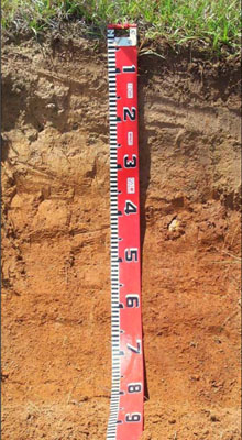 | ||
| A11 | 0 – 5 cm | Dark brown (7.5YR3/2); silty loam; weak polyhedral structure; gradual change to: | |
| A12 | 5 – 25 cm | Yellowish brown (10YR5/4); fine sandy clay loam; weak polyhedral structure; clear change to: | |
| Subsoil | |||
| B1 | 25 – 45 cm | Strong brown (7.5YR4/6); silty clay; moderate prismatic structure; gradual change to: | |
| B2 | 45 – 75 cm+ | Yellowish red (5YR4/6); silty light to medium clay; moderate prismatic structure. | |
| Comments This soil profile is very similar in appearance to EG203 and is expected to behave similarly. | |||