Victorian Resources Online (archived)
Benambra (Symbol: Ba)
EG204 | EG211 | Soil Conservation Authority, Profile No. 212
Geology
Late Pleistocene to Recent alluvial sediments.
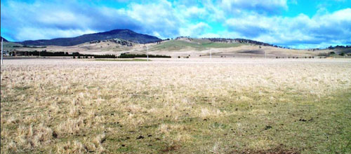
Landform
Gently undulating plain.
The Benambra map unit can be subdivided into four components. The level plains are the most extensive component and occur both east and west of Benambra. East of Benambra there are low sandy rises as well as a narrow flood plain associated with Morass Creek. The other component occurs south of Lake Omeo and is comprised of low rises, called lunettes, south-east of Lake Omeo.
Geological history
This unit occupies the relatively level area to the south-west and east of Benambra. Rowe (1984) and others believe these areas formed a once extensive lake system formed when the Morass and Deep Creeks were blocked by a basalt flow about 2.3 million years ago. Before down-cutting commenced, water must have ponded along Morass Creek for some 15 km above the basalt flow and flooded the basin now occupied by Lake Omeo up to about the 715 m contour, the approximate level of the surface of the basalt. Sediment accumulated in the basin, filling it to a maximum depth of about 80 m before Morass Creek breached the basalt. Now there is no ponding of the water except during major flood flows.
After the basin filled with sediment, geological faulting occurred resulting in a narrow long ridge running north-south through Benambra. This isolated Lake Omeo from Morass Creek. Now the plains east of Benambra are drained by Morass Creek but the plains to the south-west have no external drainage thus forming Lake Omeo. The elevation of clay plains on both sides of the ridge is very similar, about 695 – 700 m.
Alluvial plains east of Benambra
Original vegetation
Montane grassland with montane grassy woodland.
Soils
Component 1: Soils of the level plains
These soils form the majority of soils both south-west and east of Benambra. The surface soils are commonly dark grey brown fine sandy clay loams to light clays. At about 15 cm there is a clear change to dark grey medium clays with a coarse prismatic to coarse sub-angular blocky structure. Clay textures generally continue to at least 1 m with dark yellowish or greyish brown colours predominant. Sandier deep subsoils appear to adjoin the low sandy rises. Occasionally small pellets of lime (calcium carbonate) occur in the deep subsoil. Two pits were excavated for this report (EG204, EG211).
Component 2: Soils of the low sandy rises
East of Benambra there are low sandy rises. A soil pit (EG204) was excavated on the level plain adjoining one area which showed the sandier material extended below the adjoining greyer soils of the plain. This means the sandy to gravelly sediments predate the last phase of dark clay deposition. No pits were excavated on these rises. However there is a gravel pit off Limestone Road where a quarry face is exposed. The soils here are quite gravelly and show weak profile development.
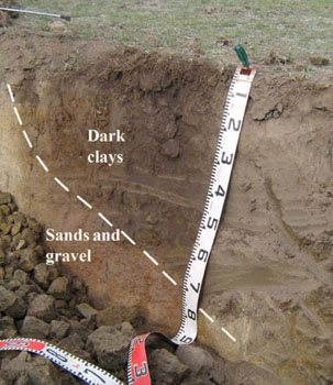 Dark clays overlay earlier deposits of sands and gravels |  Quarry face off Limestone Road |
Component 3: Soils of the narrow flood plain associated with Morass Creek
The present flood plain of Morass Creek is confined to a narrow area adjoining either side of the creek which is lower than the adjoining level plain. No pits were excavated but shallow auger holes showed the surface soils are predominantly dark grey clays which crack during dry periods. The Morass Creek is now a drain and its present flood plain is rarely under water.
Component 4: Soils of the low rises south-east of Lake Omeo
A continuous narrow low rise, called a lunette, occurs along the immediate south-east part of Lake Omeo. Rowe (1984) describes the surface soils as dark clays with a well developed structure becoming olive grey heavy clay with depth. They are neutral to slightly alkaline in the surface but become more alkaline with depth with free lime usually present. A fragmented outer lunette comprising three low rises occurs about 700 m south of the Lake. These deposits are believed to wind-blow clays derived from the dry lake bed. Rowe (1967) has described a profile on the outer lunette and his information is used here (Soil Conservation Authority, Profile No 212). Auger holes on the level plain show a similar soil profile.
| Location: Benambra (East of township) | Geo. Ref. 0564162E 5909929N |
| Australian soil classification: Sodic, Eutrophic, Black CHROMOSOL | Black texture contrast soil |
| General landscape description: Almost level plain | |
| Geology: Pleistocene to recent alluvial deposits | |
| Land use: Grazing on annual pasture | |
| Native vegetation: Montane grassland | |
| Mapping unit: Benambra (Component 1) |
Soil profile morphology
| Surface soil | 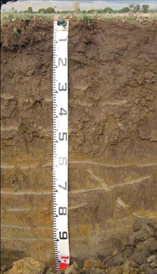 | ||
| A1 | 0 – 15 cm | Very dark greyish brown (10YR3/2); clay loam; moderate coarse (20 – 50 mm) polyhedral structure; firm consistence dry; abrupt change to: | |
| Subsoil | |||
| B21 | 15 – 45 cm | Very dark grey (10YR3/1); medium clay; strong very coarse (> 50 mm) prismatic structure; very firm to strong consistence dry; | |
| B22 | 45 – 80 cm | Brown (10YR5/3); medium clay; strong very coarse (> 50 mm) prismatic to lenticular structure; strong consistence dry; clear change to: | |
| D | 80 – 105+ cm | Yellowish brown (10YR5/6); sandy clay; apedal; strong consistence dry; becoming sandier with depth. |
Key profile features
- Texture contrast between the surface (A1) horizon and subsoil (B21) horizon.
- Strongly structured subsoils.
| pH | Salinity rating | Sodicity | Dispersion | Slaking | |
| Surface soil (A1 horizon) | Strongly acid | Very low | Non sodic | None | Water stable |
| Subsoil (B21 horizon) | Slightly acid | Very low | Non sodic | Slight1 | Slakes partially |
| Deeper subsoil (B22) | Slightly alkaline | Very low | Sodic | None | Slakes considerably |
| Horizon | Depth cm | Field texture | pH water | EC dS/m | Coarse sand % | Fine sand % | Silt % | Clay % | Field cap. % w/w | Wilt. point % w/w | PAW* water % w/w |
| A1 | 0-15 | CL | 5.3 | 0.09 | 17 | 35 | 18 | 20 | 31.4 | 11.1 | 20.3 |
| B21 | 15-45 | MC | 6.1 | <0.05 | 19 | 28.5 | 18 | 30 | 27.5 | 15.0 | 12.5 |
| B22 | 45-80 | MC | 7.7 | 0.13 | 22.5 | 31 | 16 | 26 | 26.0 | 14.4 | 11.6 |
Management considerations
Whole profile
|  |
Site EG211
| Location: Benambra (East of township) | Geo. Ref. 0563650E 5912350N |
| Australian soil classification: Eutrophic, Subnatric, Black SODOSOL | Black sodic texture contrast soil |
| General landscape description: Almost level plain | |
| Geology: Pleistocene to recent alluvial deposits | |
| Land use: Lucerne | |
| Native vegetation: Montane grassland | |
| Mapping unit: Benambra (Component 1) |
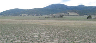
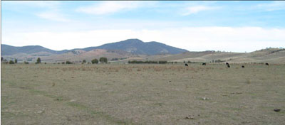
Photo taken from pit looking towards the north-east. The narrow present flood plain of
Morass Creek is in the middle ground
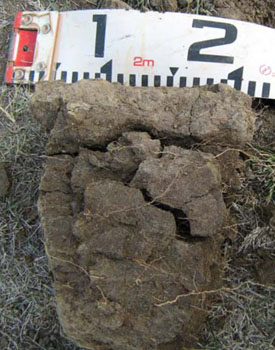
Soil profile morphology
| Surface soil |  | ||
| A1 | 0 – 25 cm | Very dark greyish brown (10YR3/2); clay loam; strong medium (10 -20 mm) granular structure; weak consistence dry; abrupt change to: | |
| Subsoil | |||
| B21 | 25 – 55 cm | Very dark greyish brown (10YR3/2); medium clay; coarse (20 – 50 mm) strong columnar structure; strong consistence dry; diffuse change to: | |
| B22 | 55 – 90 cm | Very dark greyish brown (10YR3/2) mottled with yellowish brown (10YR5/4); medium clay; coarse (20 – 50 mm) moderate prismatic structure; strong consistence dry; diffuse change to: | |
| B23 | 90 – 115 cm | Greyish brown (10YR5/2) and yellowish brown (10YR5/6) with distinct very dark greyish brown (10YR3/2) mottles; medium clay; moderate coarse (20 – 50 mm) prismatic structure; very firm consistence dry. |
- Texture contrast between the surface (A1) horizon and subsoil (B21) horizon
| pH | Salinity rating | Sodicity | Dispersion | Slaking | |
| Surface soil (A1 horizon) | Strongly acid | Low | Non sodic | None | Water stable |
| Subsoil (B21 horizon) | Slightly alkaline | Very low | Sodic | None1 | Water stable |
| Deeper subsoil 90-115 cm | Moderately alkaline | Low | Strongly sodic | Slight1 | Slakes considerably |
| Horizon | Depth cm | Field texture | pH water | EC dS/m | Coarse sand % | Fine sand % | Silt % | Clay % | Field cap. % w/w | Wilt. point % w/w | PAW* water % w/w |
| A1 | 0-25 | CL | 5.0 | 0.17 | 9 | 33 | 24 | 23 | 35.9 | 12.9 | 23.0 |
| B21 | 25-55 | MC | 6.5 | 0.06 | 11 | 29 | 19 | 36 | 30.9 | 15.9 | 25.0 |
| B22 | 55-90 | MC | 7.8 | 0.09 | 3 | 27 | 23 | 41 | 38.9 | 18.9 | 20.0 |
| B23 | 90-115 | MC | 8.2 | 0.16 | 12 | 36 | 17 | 34 | 33.4 | 16.2 | 17.2 |
| Depth | OrgC# | Total N | Exch. Al | Exchangeable cations meq/100 g | Ca:Mg | Na % | ||||||
| cm | % | % | ppm | Ca | Mg | K | Na | Total | H | CEC | ||
| 0-25 | 4.0 | 0.32 | 17 | 7.0 | 3.7 | 0.52 | 0.24 | 11 | 11.0 | 22.0 | 1.9 | 1 |
| 25-55 | 1.1 | 0.08 | 6.0 | 6.9 | 0.2 | 1.3 | 14 | 7.4 | 21.4 | 0.9 | 6 | |
| 55-90 | 0.66 | 6.2 | 7.3 | 0.25 | 2.2 | 16 | 0.9 | 14 | ||||
| 90-115 | 0.39 | 6.1 | 6.4 | 0.16 | 3.3 | 16 | 0.9 | 21 | ||||
Management considerations
Whole profile
- Plant available water is considered to be moderate, based on an effective rooting depth of 55 cm.
- The surface soil is strongly acid. However the level of exchangeable aluminium is low (17 mg/kg) and is unlikely to affect the growth of aluminium sensitive species, particularly as the soil becomes alkaline with depth. Lime can be used to increase soil pH but a pH/aluminium test is best performed by taking samples across the paddock and bulked together. The use of test strips to observe lime response could be used as an aid in evaluating its cost/benefit. At a pH of 5.0, a pH response would be expected.
- Potassium levels in the surface soil are moderate and plant responses to potassium fertiliser is unlikely.
- Salinity is not a problem in the surface soil.
- Deficiencies of molybdenum and phosphorus may occur in the strongly acid surface soils and increasing the pH by lime application should enable the phosphorus (from superphosphate) and molybdenum to become more available.
- The nutrient holding capacity of the surface (A1) horizon is moderate (based on the sum of the exchangeable calcium, magnesium, potassium and sodium cations).
- The pH increases with depth, thus allowing the successful growing of deep rooting aluminium sensitive species (e.g. lucerne).
- The coarse strong prismatic nature of the clay B horizon confines the roots to cracks and makes it difficult for the roots to fully exploit the soil. As the subsoil is sodic and the deep subsoil strongly sodic, root and downward water movement may be restricted.
| Location: Church Road, Benambra | Geo. Ref. 560800E, 590900N |
| Australian soil classification: Mottled-Sodic, Calcic, Black CHROMOSOL | Black texture contrast soil |
| General landscape description: Low lunette | |
| Site description: Road reserve | |
| Geology: Quaternary alluvial/aeolian deposits | |
| Mapping unit: Benambra (Component 4) |
No photo available
Soil profile morphology
| Surface soil | ||
| A11 | 0-7 cm | Black (10YR2/1); fine sandy clay loam; moderate 0.5-4 cm angular blocky structure; clear smooth boundary to: |
| A12 | 7-15 cm | Black (10YR2/1); fine sandy light clay; moderate 0.5-4 cm angular blocky structure; clear smooth boundary to: |
Subsoil | ||
| B21 | 15-30cm | Mottled lack and dark yellowish brown; heavy clay; strong 0.5-1 cm angular blocky structure; occasional 1 cm carbonate concretions; clear smooth boundary to: |
| B22 | 30-60 cm | Mottled black and dark yellowish brown; heavy clay; strong 1-5 cm blocky peds arranged in columns; occasional 2 cm carbonate concretions; clear smooth boundary to: |
| B23 | 60-100 cm + | Mottled olive and black; heavy clay; strong 0.5-2 cm subangular blocky peds weakly arranged in columns; calcium carbonate concretions up to 25 cm common – decreasing below 100 cm. |
Soil profile characteristics
| pH | Salinity rating | Sodicity | Dispersion | Slaking | |
| Surface soil (A1 horizon) | Moderately acid | Very low | Non sodic | ||
| Subsoil (B21 horizon) | Strongly alkaline | Medium | Non sodic | ||
| Deeper subsoil 90-115cm | Moderately alkaline | High | Sodic |
| Horizon | Depth cm | Field texture | pH water | EC dS/m | Coarse sand % | Fine sand % | Silt % | Clay % | Field cap. % w/w | Wilt. point % w/w | PAW* water % w/w | Free Fe2O3 % w/w |
| A1 | 0-7 | FSCL | 5.5 | 0.09 | 11 | 36 | 17 | 27 | ||||
| B21 | 15-30 | HC | 6.2 | 0.06 | 6 | 22 | 6 | 58 | ||||
| B22 | 30-60 | HC | 8.6 | 0.80 | ||||||||
| B23 | 60-110 | HC | 8.4 | 1.20 | 1 | 11 | 9 | 74 |
| Depth | OrgC# | Total N | Avail P | Avail K | Exch. Al | Exchangeable cations meq/100 g | Ca:Mg | Na % | ||||||
| cm | % | % | ppm | ppm | ppm | Ca | Mg | K | Na | Total | H | CEC | ||
| 0-7 | 3.5 | 0.32 | 8.8 | 5.0 | 2.1 | 0.3 | 16.2 | 1.8 | 2 | |||||
| 15-30 | 1.3 | 0.12 | 8.3 | 10.5 | 2.5 | 0.8 | 22.1 | 0.8 | 4 | |||||
| 30-60 | 0.2 | 0.04 | 10.2 | 20.2 | 2.2 | 1.3 | 34.9 | 0.5 | 4 | |||||
| 60-110 | 9.1 | 21.7 | 1.9 | 3.8 | 35.5 | 0.4 | 11 | |||||||