Carrabungla (Symbol: Ca)
Profile No. 12 (Aldrick, et al. 1992)
Geology
Devonian rhyolites and rhyodacites , (Wellington Rhyolites, Snowy River Volcanics).
Landform
The Carrabungla map unit encompasses rolling to steep hills at an elevation range of about 500 to 1000 m and a relief range of 90 to 300 m. The slope gradients exceed 15% but are generally much steeper, commonly 30 to 80%. No sites were examined for this manual, but one site was examined by Aldrick et al. (1992). All the soils are believed to be shallow, reflecting the steep slopes and the resistance of the parent materials to weathering.
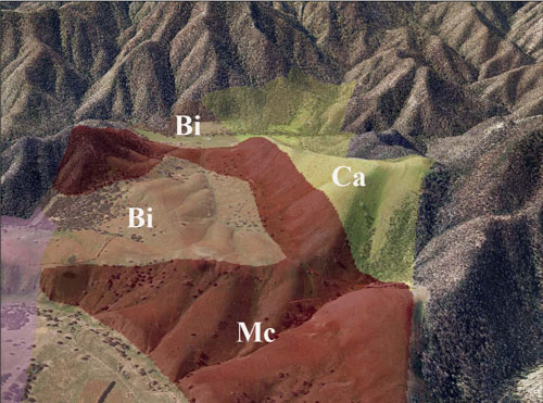
The steep cleared area in the centre of the picture is described under the Carrabungla map unit
(Vertical exaggeration 1.5)
Soils
Aldrick et al. (1992) describes the soils as being shallow and, generally between 30 cm and 1.5 m deep, with rock fragments throughout the soil profile. The description given here is from a site near Bennison Lookout in the Avon Wilderness Park.
Original vegetation
Shrubby dry forest.
Land use
Most of East Gippsland defined by this map unit remains uncleared. However an area near Bindi has been cleared, some of it only recently.
Management considerations
The risk of sheet and rill erosion is likely to be high, particularly under low grass cover following drought or overgrazing.
Profile Number 12, (Aldrick et al. 1992)
| Location: 300 m south of Bennison Lookout | Geo. Ref. 472200E 5848300N |
| Australian soil classification: Dystrophic, Brown KANDOSOL | Stony |
| General landscape description: Steep hills | |
| Geology: Devonian rhyolites and rhyodacites , (Wellington Rhyolites, Snowy River Volcanics). | |
| Site Description: Mid-slope, WSW aspect 45% slope | |
| Land use: Grazing on annual pasture | |
| Original vegetation: Shrubby dry forest | |
| Mapping unit: Carrabungla |
No photo is available
Soil profile morphology
| Surface soil | ||
| A1 | 0 – 9 cm | Very dark greyish brown (10YR3/2); stony loam; weak crumb structure; very weak consistence dry; 40% bedrock fragments up to 10 mm; clear change to: |
| Subsoil | ||
| B | 9 – 71+ cm | Yellowish brown (10YR5/6); stony clay loam; apedal; slightly hard dry; 40% bedrock fragments up to 18 mm: |
| R | 71+ cm | Bedrock. |
Key profile features
- Slight increase in texture down the soil profile.
- Shallow soil depth.
| pH | Salinity rating | Sodicity | Dispersion | Slaking | |
| Surface soil (A1 horizon) | Very strongly acid | Very low | Non sodic | ||
| Subsoil (B horizon) | Very strongly acid | Very low | Non sodic |
| Horizon | Depth cm | Field texture | pH water | EC dS/m | Gravel % | Coarse sand % | Fine sand % | Silt % | Clay % | Field cap. % w/w | Wilt. point % w/w | PAW* water % w/w |
| A1 | 0-9 | L | 4.2 | 0.07 | 39 | 22 | 18 | 25 | 15 | |||
| B | 20-30 | CL | 4.9 | 0.04 | 33 | 13 | 25 | 38 | 21 | |||
| B | 30-60 | CL | 5.0 | 0.03 | 28 | 16 | 21 | 31 | 24 |
| Depth | OrgC# | Total N | Free Fe2O3 % w/w | Exch. Al | Exchangeable cations meq/100 g | Ca:Mg | Na % | ||||||
| cm | % | % | ppm | Ca | Mg | K | Na | Total | H | CEC | |||
| 0-9 | 5.7 | 0.21 | 1.0 | 0.06 | 0.06 | 0.6 | 0.1 | 0.82 | 55.9 | 56.7 | 1 | <1 | |
| 20-30 | 1.7 | 0.08 | 1.2 | 0.07 | 0.1 | 0.7 | 0.09 | 0.96 | 24.4 | 25.4 | 0.7 | <1 | |
| 30-60 | 1.4 | 0.07 | 0.1 | 0.6 | 0.1 | 0.87 | 18.0 | 18.9 | 0.7 | 1 | |||
Management considerations
Whole profile
- The surface soil is very strongly acid and is highly likely to respond to lime applications. As both the calcium and magnesium levels are low, dolomitic lime would be the better option. It is difficult to put a figure on the lime required, but in excess of 2.5 tonnes per hectare would be required.
- With such a strongly acidic soil, the levels of exchangeable aluminium are likely to be high which tends to “fix” phosphorus and molybdenum and can be toxic to aluminium-sensitive plant species. Adding lime will help alleviate this problem.
- The potassium levels are quite high and no response to potassium fertiliser would be expected.