Dargo (Symbol: Do)
EG202 | EG207 | Profile No. 46 (Aldrick et al, 1992)
Geology
Palaeozoic granites, some coarse grained metamorphic sediments; deeply weathered.
Landform
Enclosed rolling low hills, with steep hills often adjoining stream lines. Elevation range 250 - 500 m with local relief 30 – 90 m, and typical slope gradients 8 – 20 %. Broad concave drainage lines with slope gradients generally less than 5 %.
The Dargo map unit may be subdivided into four components: moderate to gentle slopes are the most extensive component, generally without rock outcrops. Areas comprising open depressions and steep slopes generally with rock outcrop are less extensive.
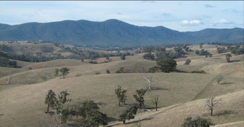
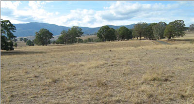
Enclosed rolling low hills and undulating footslopes, mostly cleared for grazing. The steep hills in the background
are mapped as the Bloomfield map unit.
Original vegetation
Grassy woodland.
| Soils Component 1: Soils on moderate to gentle slopes Most of the soils on this map unit are texture contrast soils, which means they have light textured surface soils (generally sandy loams) abruptly overlying a clay subsoil. The surface soils are dark brown to reddish brown sandy loams abruptly overlying reddish brown to red clay subsoils at about 25 to 50 cm. They often have a bleached subsurface (typically pale brown) similar to the surface texture. Decomposing granite generally occurs between 0.7 and 1.2 m. Surface soils range in pH from strongly acidic to slightly acidic, have low to very low organic matter and a low water and nutrient holding capacity. The strongly structured subsoil clays are well drained with pHs ranging from slightly acid to slightly alkaline. As they tend to slake considerably when wet, gully erosion may occur where water is channelled, for example along road reserves and in open depressions. (See EG202, EG207 and Profile No 46 (Aldrick et al, 1992). Component 2: Soils in open depressions Deep gullies have formed in many of the open depressions. The exposed gully walls reveal a range of soils from very dark grey clays to yellow texture contrast soil. No soils were examined on this unit. Component 3: Steep slopes Steep slopes, ranging from 20 – 50% or more, often adjoin the streams and major drainage lines. Rock is frequently exposed at the surface. No soils were examined on this unit. | 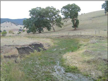 Dark grey clays in a drainage line near Dargo |
Site EG202
| Location: Doctors Flat | Geo. Ref. 0567255E 5869452N |
| Australian soil classification: Eutrophic, Subnatric, Red SODOSOL | Red sodic texture contrast soil |
| General landscape description: Rolling low hills | |
| Geology: Palaeozoic granite | |
| Site Description: Mid north-west facing slope (8% slope) | |
| Land use: Grazing on annual pasture | |
| Original vegetation: Grassy woodland | |
| Mapping unit: Dargo (Component 1) |
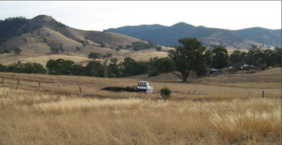
Rolling low hills of the Dargo map unit in the foreground, steep hills of the Bloomfield map unit in the background
Soil profile morphology
| Surface soil | 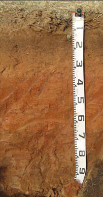 | ||
| A1 | 0 – 20 cm | Reddish brown (10YR4/3); sandy loam; weak fine (2 – 10 mm) granular structure; weak consistence dry; clear change to: | |
| A2 | 20 – 35 cm | Yellowish red (10YR5/6); sandy loam (light); apedal; firm consistence dry; abrupt change to: | |
| Subsoil | |||
| B21 | 35 – 60 cm | Red (2.5YR4/6); light medium clay; weak coarse (20 – 50 mm) polyhedral structure; strong consistence dry; gradual change to: | |
| B22 | 60 – 90+ cm | Reddish brown (5YR5/4); medium clay; moderate coarse (20 – 50 mm) lenticular structure; strong consistence dry; very few (<2 %) fine manganiferous veins. | |
Key profile features
- Strong texture contrast between the surface (A) horizons and the subsoil (B) horizons.
| pH | Salinity rating | Sodicity | Dispersion | Slaking | |
| Surface soil (A1 horizon) | Slightly acid | Very low | Non sodic | None1 | Slakes partially |
| Subsoil (B21 horizon) | Slightly alkaline | Very low | Strongly sodic | Strong2 | Slakes considerably |
| Deeper subsoil (60-90cm) | Slightly alkaline | Very low | Strongly sodic | Strong2 | Slakes considerably |
| Horizon | Depth cm | Field texture | pH water | EC dS/m | Coarse sand % | Fine sand % | Silt % | Clay % | Field cap. % w/w | Wilt. point % w/w | PAW* water % w/w | Free Fe2O3 % w/w |
| A1 | 0-20 | SL | 6.1 | 0.06 | 40 | 40 | 9 | 7 | 12.5 | 4.0 | 8.5 | |
| A2 | 20-35 | SL | 6.1 | 0.05 | 39 | 44 | 9 | 5 | 9.4 | 3.2 | 6.2 | |
| B21 | 35-60 | LMC | 7.5 | 0.06 | 31 | 32 | 10 | 23 | 20.9 | 11.0 | 9.9 | |
| B22 | 60-90 | MC | 7.9 | 0.16 | 23 | 22 | 8 | 43 | 33.9 | 18.6 | 15.3 |
| Depth | OrgC# | Total N | Exch. Al | Exchangeable cations meq/100 g | Ca:Mg | Na % | ||||||
| cm | % | % | ppm | Ca | Mg | K | Na | Total | H | CEC | ||
| 0-20 | 1.5 | 0.09 | <10 | 3.8 | 0.58 | 0.24 | 0.16 | 4.8 | 3.6 | 8.4 | 6.6 | 2 |
| 20-35 | 0.54 | <0.05 | <10 | 2.1 | 0.4 | 0.17 | 0.17 | 2.8 | 1.9 | 4.7 | 5.2 | 4 |
| 35-60 | 0.38 | N/A | 4.4 | 3.1 | 0.16 | 1.1 | 8.7 | 2.5 | 11.2 | 1.4 | 12 | |
| 60-90 | 0.45 | N/A | 7.2 | 8.7 | 0.3 | 3.6 | 20 | 0.8 | 18 | |||
Management considerations
Whole profile
- Plant available water content for this profile is considered to be very low, as the effective rooting depth is largely limited to the surface horizons due to the dense and coarsely structured nature of the strongly sodic subsoil.
- The low wilting point (4 and 3.2%) of the surface soils indicates the plants are able to utilise very light rains when the soil is dry. However, due to the low water storage capacity, plants will soon suffer moisture stress unless further rains occur.
- The organic matter content of the soil is very low. Such levels result in a very poor structural condition and very low structural stability.
- The surface soil is moderately acid. As the pH is well above 5.5, a pasture response to lime additions is unlikely.
- Potassium is low to deficiency levels for pastures.
- Salinity is not a problem in the surface soil.
- The nutrient holding capacity of the surface (A1 and A2) horizons is very low (based on the sum of the exchangeable calcium, magnesium, potassium and sodium cations).
- The dense and coarsely structured upper subsoil is strongly sodic. Root and water movement is likely to be restricted although the red colour of the subsoil indicates the soil is generally well drained. Gypsum in association with deep ripping has been used to ameliorate sodic subsoils but here this would be not an economic option.
- The subsoil and the deep subsoil are strongly dispersive. If the subsoil is exposed, for example by a gully head, headward erosion is highly likely.
| Location: Doctors Flat | Geo. Ref. 0567255E 5869452N |
| Australian soil classification: Eutrophic, Subnatric, Red SODOSOL | Red sodic texture contrast soil |
| General landscape description: Rolling low hills | |
| Geology: Palaeozoic granite | |
| Site Description: Mid north-west facing slope (8% slope) | |
| Land use: Grazing on annual pasture | |
| Original vegetation: Grassy woodland | |
| Mapping unit: Dargo (Component 1) |
Soil profile morphology
| Surface soil | 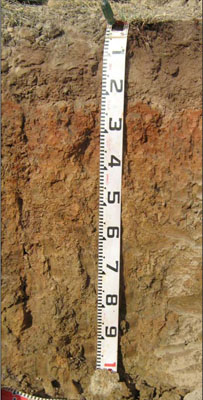 | ||
| A1 | 0 – 15 cm | Dark brown (10YR4/3); sandy loam; weak fine (2 – 5 mm) granular structure; weak consistence dry; clear change to: | |
| A2 | 15 – 20/25 cm | Very pale brown (10YR7/4) conspicuously bleached (10YR8/3d); sandy loam; apedal; very weak consistence dry; many (20 – 50 %) coarse (6 – 20 mm) ferruginous concretions; sharp wavy change to: | |
| Subsoil | |||
| B21 | 20/25 – 45 cm | Yellowish red (5YR5/6); medium clay; moderate medium (10 -20 mm) angular blocky structure; strong consistence dry; diffuse change to: | |
| B22 | 45 – 75 cm | Reddish brown (10YR5/4); medium clay; weak medium (10 -20 mm) angular blocky structure; strong consistence dry; few (2 – 10 %) manganiferous veins; diffuse change to: | |
| B23 | 75 – 110 cm | Light reddish brown (10YR6/4); medium clay with sand; very strong consistence dry; very few (<2 %) manganiferous veins |
Key profile features
- Strong texture contrast between the surface (A) horizons and the subsoil (B) horizons.
| pH | Salinity rating | Sodicity | Dispersion | Slaking | |
| Surface soil (A1 horizon) | Strongly acid | Very low | Non sodic | None | Water stable |
| Subsoil (B21 horizon) | Slightly acid | Very low | Sodic | Slight | Slakes considerably |
| Deeper subsoil (75-110cm) | Strongly alkaline | Low | None | Slakes considerably |
| Horizon | Depth cm | Field texture | pH water | EC dS/m | Coarse sand % | Fine sand % | Silt % | Clay % | Field cap. % w/w | Wilt. point % w/w | PAW* water % w/w | Free Fe2O3 % w/w |
| A1 | 0-15 | SL | 5.1 | 0.1 | 43 | 37 | 9 | 4 | 11.8 | 3.6 | 8.2 | |
| A2 | 15-20/25 | SL | 5.5 | <0.05 | 41 | 38 | 11 | 6 | 11.5 | 2.5 | 9.0 | |
| B21 | 20/25-45 | MC | 6.5 | 0.08 | 12 | 26 | 12 | 47 | 31.1 | 18.2 | 12.9 | |
| B22 | 45-75 | MC | 7.6 | 0.14 | 20 | 28 | 13 | 36 | 26.9 | 14.8 | 12.1 | |
| B23 | 75-110 | MC | 8.7 | 0.33 | 21 | 23 | 12 | 40 | 33.7 | 17.4 | 16.3 |
| Depth | OrgC# | Total N | Exch. Al | Exchangeable cations meq/100 g | Ca:Mg | Na % | ||||||
| cm | % | % | ppm | Ca | Mg | K | Na | Total | H | CEC | ||
| 0-15 | 1.6 | 0.12 | 16 | 1.3 | 0.52 | 0.48 | 0.11 | 2.4 | 6.3 | 8.7 | 2.5 | 1 |
| 15-20/25 | 0.66 | <0.05 | 19 | 0.79 | 0.52 | 0.24 | 0.07 | 1.6 | 4.6 | 6.2 | 1.5 | 1 |
| 20/25-45 | 0.54 | 4.8 | 9.1 | 1.1 | 0.82 | 15.8 | 2.5 | 0.5 | 4 | |||
| 45-75 | 0.41 | 3.6 | 11 | 0.39 | 1.5 | 16.5 | 0.3 | 9 | ||||
| 75-110 | 0.3 | |||||||||||
Management considerations
Whole profile
- Plant available water content for this profile is considered to be low, as the effective rooting depth is largely limited to the surface horizons due to the dense and coarsely structured nature of the subsoil.
- The low wilting points (3.5 and 2.5 %) of the surface soils indicates the plants are able to utilize very light rains when the soil is dry. However, due to the low water storage capacity, plants will soon suffer moisture stress unless further rains occur.
- The surface soil is strongly acid. However the level of exchangeable aluminium is reasonably low (16 mg/kg) and is unlikely to affect the growth of aluminium sensitive species, except the most sensitive. Lime can be used to increase soil pH but a pH/aluminium test is best performed by taking samples across the paddock and bulked together. The use of test strips to observe lime response could be used as an aid in evaluating its cost/benefit. For this soil a response to lime (about 1-2 tonnes/ha) would be expected.
- The organic matter content of the soil is low. Such levels result in a poor to moderate structural condition and low to moderate structural stability.
- Potassium is at a moderate level for pastures and no response to potassium fertilisers would be anticipated.
- Salinity is not a problem in the surface soil.
- The nutrient holding capacity of the surface (A1 and A2) horizons is very low (based on the sum of the exchangeable calcium, magnesium, potassium and sodium cations).
- Root and water movement is likely to be restricted in the dense and coarsely structured subsoil although the red colour of the subsoil indicates the soil is generally well drained.
- The roots tend to follow cracks between the soil aggregates and can only extract part of the soil water.
- The subsoil and the deep subsoil are slightly dispersive but slake considerably. If the subsoil is exposed, for example by a gully head, headward erosion is highly likely.
| Location: Tongio | Geo. Ref. 0561700E 5885400N |
| Australian soil classification: Eutrophic, Brown CHROMOSOL | Brown texture contrast soil |
| General landscape description: Rolling low hills | |
| Geology: Palaeozoic granite | |
| Site Description: Upper south-west facing slope (15% slope) | |
| Land use: Grazing on annual pasture | |
| Original vegetation: Open forest | |
| Mapping unit: Dargo (Component 1) |
No photo available
Soil profile morphology
| Surface soil | ||
| A11 | 0-12 cm | Dark brown (7.5YR3/2) sandy loam; weak crumb structure; hard consistence dry; clear change to: |
| A12 | 12-36 cm | Dark brown (7.5YR3/2) gritty sandy loam; apedal; hard consistence dry; about 30% of fine quartz gravel up to 3mm; clear change to: |
| A13 | 36-52 cm | Strong brown (7.5YR5/6) gritty sandy loam; hard consistence dry; about 30% of fine quartz gravel up to 3mm; clear change to: |
Subsoil | ||
| B2 | 50-7 0cm | Strong brown (7.5YR4/6) becoming yellowish red (5YR5/6) with depth; medium clay; moderate angular blocky structure (10 mm); very hard dry; gradual change to: |
| C | 70-83 cm+ | Sandy clay; apedal; very hard dry; biotite, plagioclase feldspar, quartz and a small amount of muscovite clearly visible (minerals comprising granite) |
Soil profile characteristics
| Horizon | Depth cm | Field texture | pH water | EC dS/m | Gravel % | Coarse sand % | Fine sand % | Silt % | Clay % | Field cap. % w/w | Wilt. point % w/w | PAW* water % w/w |
| A11 | 0-10 | SL | 6.2 | 0.05 | 11 | 34 | 36 | 15 | 12 | |||
| A12 | 20-30 | SL | 6.5 | <0.05 | 15 | 38 | 36 | 18 | 7 | |||
| A13 | 36-52 | SL | 6.7 | <0.05 | 20 | 38 | 31 | 14 | 16 | |||
| B2 | 52-60 | MC | 6.3 | <0.05 | 16 | 16 | 16 | 5 | 63 | |||
| C | 70-83 | SC | 6.4 | <0.05 | 21 | 28 | 25 | 10 | 34 |
| Depth | Org C# | Total N | Exch. Al | Exchangeable cations meq/100 g | Ca:Mg | Na % | ||||||
| cm | % | % | ppm | Ca | Mg | K | Na | Total | H | CEC | ||
| 0-10 | 2.2 | 0.2 | 4.5 | 1.3 | 0.5 | 0.08 | 6.4 | 8.2 | 14.6 | 3.5 | 1 | |
| 20-30 | 0.76 | 0.31 | 3.9 | 0.5 | 0.2 | 0.02 | 4.6 | 3.6 | 8.2 | 7.8 | <1 | |
| 36-52 | 3.6 | 0.8 | 0.3 | 0.07 | 4.8 | 3.0 | 7.8 | 4.0 | 1 | |||
| 52-60 | 9.3 | 2.9 | 0.5 | 0.3 | 13.0 | 12.1 | 25.1 | 3.2 | 1 | |||
| 70-83 | 9.3 | 3.1 | 0.5 | 0.4 | 13.3 | 7.9 | 21.2 | 3.0 | 2 | |||
Management considerations
Whole profile
- Plant available water content for this profile is considered to be moderate as the effective rooting depth is likely to extend to 0.5 m into the sandy loam surface soils.
- The low clay content of the surface soils indicates the plants are able to utilise very light rains when the soil is dry.
- The organic matter content of the soil is moderate. Such levels result in an average structural condition and average structural stability.
- The surface soil is slightly acid. However it is not acidic enough to expect a response to lime applications.
- Potassium is at a moderate level for pastures and no response to potassium fertilisers would be anticipated.
- Salinity is not a problem in the surface soil.
- The nutrient holding capacity of the surface (A11 to A13) horizons is low (based on the sum of the exchangeable calcium, magnesium, potassium and sodium cations).
- Root and water movement is likely to be restricted in the dense blocky structured subsoil although the strong brown colour of the subsoil indicates the soil is generally well drained. As the surface soils are deep, water availability would be at the higher end of the scale for other soils in the area.