Map Unit A (Symbol: A)
EG59
Geology
High level Quaternary (Neogene) alluvium and colluvium.
Landform
Terrace, relatively flat with dissected edges. A terrace is a former flood plain which has become inactive because deepening or enlargement of the stream has lowered the level of flooding.
Alluvial terraces situated at heights up to 45 m above the channels of Livingstone Creek and Dry Hill Creek occur in this area. Livingstone Creek and tributaries have been rejuvenated, down cutting to new base levels through their old flood plain. This rejuvenation may have been related to movements along the Livingstone Fault. Cliffs in the terrace produced by river incision and also by past gold sluicing operations, expose deposits of gravels, sands, and silty sands. (Source: Victorian Resources Online: Sites of geological significance – East Gippsland.)
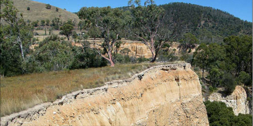
Map Unit A: The alluvial and colluvial terraces near the junction of Dry Hill and Livingston Creeks.
Areas here were sluiced for gold mining.
Original vegetation:
Montane grassy woodland with heathy dry forest.
Soils
All the soils are on deep colluvium and alluvium derived from the Palaeozoic sediments and granites which are higher up the landscape. The surface soils are generally dark greyish brown sandy to gravelly with a strongly bleached subsurface soil of similar texture. Brown to pale brown clays with varying amounts of gravel occurs from about 40 to 70 cm. Gravelly clays to gravelly sands occur to depths exceeding 2 m. It is likely that most of the surface soils and subsoils are strongly acidic.
Land use
Some of the area is cleared and used for grazing but the area north of the Omeo to Hotham Road is set aside as a historical reserve.
Site EG59
| Location: Omeo west | Geo. Ref. 0551113E 5892384N |
| Australian soil classification: Bleached, Eutrophic, Red Chromosol | Red texture contrast soil |
| General landscape description: Alluvial terrace | |
| Geology: Pleistocene (Neogene) alluvium and colluvium. | |
| Site description: Alluvial terrace, Simple slope, gradient unspecified | |
| Land use: Grazing on annual pasture | |
| Native vegetation: Montane grassy woodland | |
| Mapping unit: Minor map unit A |
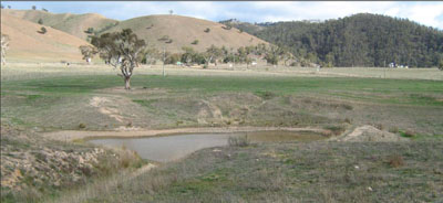
Alluvial terrace near where soil samples were taken. The Livingston Fault formed the steep hills in the background.
No soil pit photo available, but the deep profile exposed in the first photo serves as an indication.
Soil profile morphology
| Surface soil | ||
A1 | 0 – 10 cm | Dark brown (10YR4/3); fine sandy loam; weak polyhedral structure; clear change to: |
| A2 | 10 - 20 cm | Pinkish grey (7.5YR6/3); conspicuously bleached (7.5YR7/2d); fine sandy loam; apedal; very firm consistence, dry; clear change to: |
Subsoil | ||
| B21 | 20 – 40 cm | Reddish brown (5YR4/4); medium clay; strong angular blocky structure; strong consistence dry; common (10 – 20%) medium (6 – 20 mm) rounded pebbles; clear change to: |
| B22 | 40 – 60+ cm | Reddish brown (5YR4/4); medium clay; weak angular blocky structure; strong consistence dry; common abundant medium (6 – 20 mm) and large (20 – 60 mm) pebbles. |
Key profile features
- Strong texture contrast between the surface soils (A1 and A2 horizons).
- High amounts of gravel in the subsoil.
Soil profile characteristics
| pH | Salinity rating | Sodicity | Dispersion | Slaking | |
| Surface soil (A1 horizon) | Strongly acid | Very low | Non sodic | None# | Slakes partially |
| Subsoil (B1 horizon) | Strongly acid | Very low | Non sodic | None# | Slakes partially |
| Deeper subsoil (70 -110 cm) | Strongly acid | Very low | Non sodic | None* | Slakes partially |
*Slight dispersion after 20 hours following remoulding
| Horizon | Depth cm | Field texture | pH water | pH CaCl2 | EC dS/m | Coarse sand % | Fine sand % | Silt % | Clay % | Field cap. % w/w | Wilt. point % w/w | PAW* water % w/w |
| A1 | 0-10 | FSL | 5.3 | 4.6 | 0.09 | 24 | 38 | 14 | 22 | 21.6 | 8.0 | 13.6 |
| A2 | 10-20 | FSL | 5.4 | 4.7 | 0.05 | 23 | 46 | 18 | 13 | 18.3 | 4.4 | 13.9 |
| B21 | 20-40 | MC | 5.5 | 4.8 | 0.11 | 9 | 14 | 6 | 66 | 35.1 | 21.0 | 14.1 |
| Depth | OrgC# | Total N | Free Fe2O3 % w/w | Exch. Al | Exchangeable cations meq/100 g | Ca:Mg | Na % | ||||||
| cm | % | % | ppm | Ca | Mg | K | Na | Total | H | CEC | |||
| 0-10 | 2.1 | 0.14 | 4.6 | 2.4 | 2.0 | 0.73 | 0.1 | 5.3 | 8.3 | 13.6 | 1.2 | ||
| 10-20 | 13 | 1.4 | 0.91 | 0.35 | 0.06 | 2.8 | 4.5 | 7.3 | 1.5 | ||||
| 20-40 | 35 | 6.2 | 6.5 | 0.95 | 0.36 | 14.0 | 12.0 | 26.0 | 1.0 | 1 | |||
Management considerations
Whole profile
- The soil shows marked texture contrast between the surface soil and the subsoil.
- Plant available water content is moderate, based on a root depth of 50 cm. The dense and coarsely structured subsoil is likely to restrict root growth and confine most of the roots to the surface soil.
- Roots will be impeded by the very stony subsoil.
- The soil profile is strongly acid throughout.
- The whole profile has very low amounts of soluble salts.
- The low wilting points (8.0 and 4.4 %) of the surface soils indicates the plants are able to utilize very light rains when the soil is dry. However, due to the low water storage capacity, plants will soon suffer moisture stress unless further rains occur.
- The surface soils are strongly acid. However the level of exchangeable aluminium is low and is unlikely to affect the growth of aluminium sensitive species, except the most sensitive. Lime can be used to increase soil pH but a pH/aluminium test is best performed by taking samples across the paddock and bulked together. The use of test strips to observe lime response could be used as an aid in evaluating its cost/benefit. For this soil a response to lime (about 2 tonnes/ha) would be expected.
- The organic matter content of the soil is low for such a high rainfall area. Such levels result in a low structural condition and low structural stability. Careful pasture management is needed to increase organic matter levels.
- Potassium is high and no response to potassium fertilisers would be expected.
- The nutrient status of the surface (A1 and A2) horizons is low (based on the sum of the exchangeable calcium, magnesium, potassium and sodium cations). The addition of lime will increase the Ca:Mg ratio and the exchangeable calcium.
- The bleached subsurface layer lacks structure, sets hard when dry, impedes plant growth and slakes partially when wet.
- The strongly structured clay subsoil is non-sodic and does not disperse. These soils appear to be strongly structured which should allow good root penetration.
- Root movement is likely to be restricted in the gravelly deep subsoil. Reddish colours indicate the soil is well drained internally.