Victorian Resources Online (archived)
Talbotville (Symbol: Te)
Profile No. 11 (Aldrick et al, 1967)
Geology
Palaeozoic sediments, mudstones, siltstones, sandstones and shales, occasionally metamorphosed.
Landform
In the context of this report, the Talbotville map unit encompasses rolling to steep hills with an elevation range of about 350 to 1200 m. The slope gradients exceed 15% but are generally much steeper, commonly 40 – 70%. The relief ranges from 90 – 300 m.
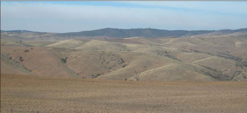
Talbotville map unit: Looking east from the Omeo Valley Road
| Soils Steep slopes, slow-weathering sedimentary rocks and rainfall inadequate enough to support vigorous and dense vegetation, give rise to active natural erosion and slow soil formation. Thus the soils tend to be shallow, stony, leached, acidic and weakly structured. Where areas have been denuded of vegetation, for example north of Smoking Hill where it was removed to support the mining industry, the soils are prone to severe sheet erosion. On the valley floors where eroded soil has accumulated, gully erosion can be quite severe. Vegetation Shrubby dry forest with montane dry woodland at higher altitudes. Profile No. 11 (Aldrick, et al 1992)
|
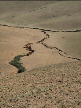 Severe gully erosion often occurs in the cleared valleys |
Soil profile morphology
| Surface soil | 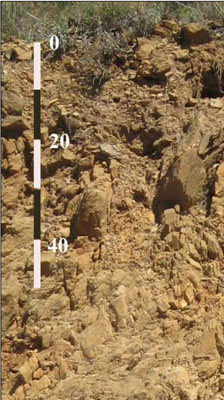 Photo: Typical Talbotville soil profile: Cutting along Omeo-Benambra Road | ||
| A1 | 0 – 5 cm | Dark brown to brown (7.5YR4/4); gravelly clay loam; apedal; slightly hard dry; 30% small bedrock fragments up to 20 mm, clear boundary to: | |
| Subsoil | |||
| B | 5 – 22 cm | Strong brown (7.5YR5/6); gravelly clay loam; apedal; friable, moist; 30% small bedrock fragments up to 20 mm; fragments up to 80 cm common below 10 cm, change to: | |
| R | 22+ cm | Bedrock | |
Key profile features
| |||
Soil profile characteristics
| Horizon | Depth cm | Field texture | pH water | pH CaCl2 | EC dS/m | Coarse sand % | Fine sand % | Silt % | Clay % | Field cap. % w/w | Wilt. point % w/w | PAW* water % w/w |
| A1 | 0-5 | ZL | 4.8 | <0.05 | 18 | 18 | 31 | 19 | ||||
| B | 5-10 | ZL | 5.0 | <0.05 | 15 | 23 | 34 | 23 | ||||
| B | 10-20 | ZCL | 5.0 | <0.05 | 13 | 22 | 35 | 28 |
| Depth | Org C# | Total N | Free Fe2O3 % w/w | Exch. Al | Exchangeable cations meq/100 g | Ca:Mg | Na % | ||||||
| cm | % | % | ppm | Ca | Mg | K | Na | Total | H | CEC | |||
| 0-5 | 3.8 | 0.19 | 2.6 | 0.05 | 0.09 | 0.7 | 0.07 | 0.9 | 30.5 | 31.4 | <1 | ||
| 5-10 | 1.8 | 0.11 | 2.9 | <0.05 | 0.05 | 0.7 | 0.09 | 0.9 | 20.7 | 21.6 | <1 | ||
| 10-20 | 1.8 | 0.10 | 3.3 | <0.05 | 0.08 | 0.7 | 0.05 | 0.9 | 21.2 | 22.1 | <1 | ||
Management considerations
Whole profile
- Plant available water will be low for pasture species where the roots are unable to find their way through cracks in the rock.
- The shallow soils have extremely low nutrient and water holding capacity.
- The surface soils are strongly acid. If pastures are to grow the soils need lime and heavy amounts of fertiliser. They are best left under native vegetation.