Victorian Resources Online (archived)
LP51
| Property: LP51 Mitiamo | Group: Pine Grove Farm Advance |
| Australian Soil Classification: Calcic, Mottled-Mesonatric, Red SODOSOL | Northcote Factual Key: Dr 2.33 |
| Great Soil Group: red-brown earth | |
| General Landscape Description: | |
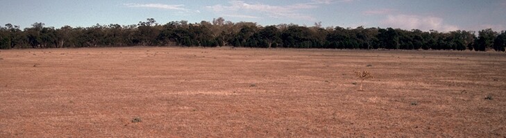 LP51Landscape |
Soil Profile Morphology
Surface Soil
| A1 | 0-12 cm | Dark brown (7.5YR3/4); fine sandy clay loam; hardsetting and massive; strong consistence dry; pH 5.9; abrupt change to: | 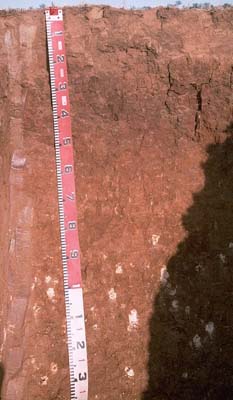 LP51 profile |
| A2 | 12-15 cm | Yellowish red (5YR4/6) sporadically bleached; coarse sandy clay loam; massive; strong consistence dry; contains a few (5%) quartz fragments; pH 6.6; sharp change to: | |
| Subsoil | |||
| B21 | 15-30 cm | Dark reddish brown (2.5YR3/4) and yellowish red (5YR5/8); medium clay; strong coarse blocky structure (with smooth-faced peds); strong consistence dry; pH 8.1; gradual change to: | |
| B22 | 30-60 cm | Yellowish red (5YR4/6); light medium clay; strong coarse blocky structure (with smooth-faced peds); strong consistence dry; pH 8.8; gradual change to: | |
| B23 | 60-85 cm | Yellowish red (5YR5/8); light medium clay; moderate medium to coarse polyhedral structure; very firm consistence dry; pH 9.0: | |
| B24k | 85 cm+ | Yellowish red (5YR5/6); light medium clay; strong medium polyhedral structure; very firm consistence dry; fine-earth carbonate common (10%); pH 9.0. | |
NOTE: This soil corresponds to Sylvaterre Sandy Clay Loam as mapped by Skene (1971). It has developed on both colluvial and aeolian (parna) materials. | |||
Key Profile Features
- Strong texture contrast between surface (A) horizons (clay content 15%) and subsoil (B21) horizon (clay content 48%).
- Hardsetting surface horizon (with high fine sand content of 46%).
- Coarsely structured (strongly sodic) subsoil.
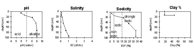
Key Profile Characteristics
pH | Salinity Rating | |||
Surface (A1 horizon) | moderately alkaline | low | non-sodic | none |
Subsoil (B21 horizon) | moderately alkaline | low | strongly sodic | complete |
Deeper subsoil (at 1 m) | strongly alkaline | medium-high | strongly sodic | - |
 |
Horizon | Horizon Depth | pH (water) | EC 1:5 | NaCl | Exchangeable Cations | |||
Ca | Mg | K | Na | |||||
meq/100g | ||||||||
A1 | 0-12 | 5.9 | 0.08 | 5.1 | 1 | 0.6 | 0.1 | |
A2 | 12-15 | 6.6 | 0.05 | 4.5 | 1.5 | 0.4 | 0.3 | |
B21 | 15-30 | 8.1 | 0.17 | 9 | 6.7 | 0.5 | 3.3 | |
B22 | 30-60 | 8.8 | 0.29 | <0.05 | 10 | 8.9 | 0.6 | 6.1 |
B23 | 60-85 | 9 | 0.65 | 0.06 | 8.4 | 8.3 | 0.7 | 8.3 |
B24k | 85+ | 9 | 1.03 | 0.17 | 9 | 8.6 | 0.7 | 8.8 |
Horizon | Horizon Depth | Ex Al mg/kg | Ex Ac meq/100g | Field pF2.5 | Wilting Point pF4.2 | Coarse Sand (0.2-2.0mm) | Fine Sand (0.02-0.2mm) | Silt (0.002-0.02mm) | Clay (<0.002mm) |
A1 | 0-12 | 19.4 | 9.5 | 20 | 46 | 16 | 16 | ||
A2 | 12-15 | 14.7 | 8.5 | 20 | 46 | 17 | 17 | ||
B21 | 15-30 | 36.7 | 24.6 | 14 | 27 | 10 | 48 | ||
B22 | 30-60 | ||||||||
B23 | 60-85 | ||||||||
B24k | 85+ |
Management Considerations:
- In general, management strategies for all soils should aim to increase organic matter levels in the surface soil; minimise the degradation of soil aggregates and porosity; promote the development of stable biopores; improve the calcium status of the ion exchange complex (particularly when sodium is a significant part – i.e. sodic), and break up any hardpans. Less frequent tillage; using less aggressive implements, and working the soil at optimum moisture conditions can all assist in maintaining soil aggregation and porosity as well as reducing the breakdown of organic matter. Practices such as residue retention, minimum tillage and including pasture rotations could be utilised if cropping takes place in order to build up organic matter, reduce erosion risk and increase fertility.
- Plant available water capacity (PAWC) is relatively low (estimated at 60 mm) for this profile - based on the laboratory data available. PAWC is limited by the strongly sodic subsoil.
Surface (A) Horizons
- The surface horizon is hardsetting and has a high fine sand content (i.e. 46%). Upon wetting and drying the surface soil sets hard and will be difficult to work and may become “powdery” when worked in a dry condition. Cultivation of such soils when wet may result in surface sealing upon drying. Tillage should be minimised and stubble retention/ pasture rotations practised.
- The organic carbon value is low for the surface soil. Soils such as these with high fine sand and silt levels depend on organic matter for maintaining structure. Improving soil organic matter levels will assist in minimising structural problems such as surface sealing and hardsetting as well as improving soil fertility and water holding capacity.
- The subsurface (A2) horizon disperses strongly after remoulding. This indicates that it may disperse if excessively cultivated or overstocked when wet. This may lead to the development of a cultivation pan.
Subsoil (B) Horizons
- The coarsely structured subsoil is strongly sodic and disperses completely in water. This is likely to result in restricted root and water movement through the profile. The presence of a sporadically bleached subsurface (A2) horizon above the sodic subsoil indicates that water movement is restricted.
- From 60 cm depth, the soil salinity rating is medium, and increases with depth. This is likely to restrict the growth of deeper-rooted salt sensitive species.
Landholder Comments:
- Gypsum has been applied and the paddock ripped to 30 cm.
- Waterlogging occurs and the surface soil becomes sloppy.
- Wheat grows better on site LP50 than here.
Notes:
Profile described by Mark Imhof, Paul Rampant and Karen de Plater (2/3/95).