Victorian Resources Online (archived)
Silver Creek (Sc)
|
Geology |  | 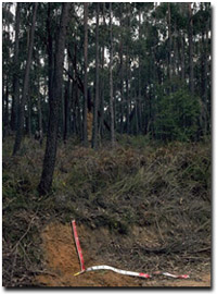 Typical soil and landscape in Silver Creek mapping unit |
| Soils These soils have been described by Poutsma and Turvey (1979) in their Silver Creek mapping unit. They are generally friable (when moist) with a dark greyish brown to dull brown loam, silty loam or light clay loam surface, overlying a weakly structured yellowish brown to brown clay loam or light clay subsoil. A yellowish brown mottled, denser clay occurs in the deeper subsoil. These soils are generally classified as Brown and Yellow Kandosols or Dermosols using the Australian Soil Classification. No pits have been sampled within this mapping unit but soil type descriptions can be found in Poutsma and Turvey (1979). | ||
Soil Pit Sites CFTT4 and CFTT8 are examples of Acidic Brown Dermosols.
Silver Creek with Morwell (Sc/Mr)
This mapping unit describes areas comprising mostly the Silver Creek mapping unit with some areas of the Morwell mapping unit. The percentage of the dominant mapping unit is at least 70%.