Victorian Resources Online (archived)
GP65
| Location: Nambrok. | Australian Soil Classification: Mottled-Sodic, Eutrophic, Brown CHROMOSOL. |
| Geology: Pleistocene sediments. | General Landscape Description: Level plain (0-1% slope). |
| Mapping Unit: Wooundellah. | Site Description: Grazing paddock. |
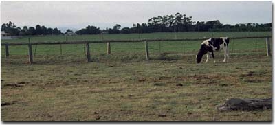 Site GP65 Landscape |
Soil Profile Morphology:
Surface Soil
| A1 | 0-5 cm | Dark brown (10YR3/3); sandy loam; weak to moderate fine polyhedral structure; weak consistence dry; pH 5.5; clear change to: | 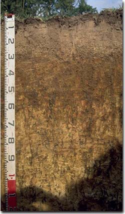 Site GP65 Profile |
A2 | 5-15 cm | Dark yellowish brown (10YR4/4); sporadically bleached; sandy loam; massive structure; strong consistence dry; contains a few (3%) rounded manganese (2-5 mm in size) as well as a few (3%) quartz gravels (2-5 mm in size); pH 5.5; clear change to: | |
| A3 | 15-25 cm | Brown (10YR4/3) with yellowish brown (10YR5/6) mottles; sandy clay loam; massive structure; strong consistence dry; manganese segregations (2-10 mm in size) and quartz gravel (2-5 mm in size) common (10%); pH 6.4; abrupt change to: | |
| Subsoil | |||
| B21 | 25-50 cm | Yellowish brown (10YR5/6) with dark red (2.5YR4/6) mottles; medium clay; strong medium polyhedral, parting to strong fine polyhedral structure; very firm consistence slightly moist; smooth faced peds; pH 6.3: | |
| B22 | 50-65 cm | Brown (10YR4/3) with dark yellowish brown (10YR4/6) and dark red (2.5YR4/6) mottles; medium clay (sandy); strong medium polyhedral, parting to strong fine polyhedral structure; strong consistence slightly moist; contains a few (5%) quartz crystals (2-5 mm in size); pH 7.1: | |
| B23 | 65-90 cm | Brownish yellow (10YR6/8); light medium clay (sandy); moderate coarse prismatic, parting to moderate coarse polyhedral structure; strong consistence dry; quartz fragments (2-5 mm in size) common (10-20%); pH 7.8; sharp change to: | |
| B24 | 90-120 cm | Brownish yellow (10YR6/8) [with brown (10YR4/3) infills]; medium clay (fine sandy); moderate coarse polyhedral structure; strong consistence slightly moist; pH 8.0. | |
Key Profile Features:
- Strong texture contrast between surface (A) horizons and subsoil (B21) horizon.
Soil Profile Characteristics:
Horizon | pH | Salinity Rating | ||
Surface (A1 horizon) | Strongly Acid | High | Non-Sodic | None |
Subsoil (B21 horizon) | Slightly Acid | Very Low | Non-Sodic | None |
Deeper subsoil (at 1 m) | Moderately Alkaline | Very Low | Strongly Sodic | Strong1 |
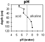 | The surface is strongly acid. The upper subsoil is slightly acid becoming moderately alkaline at 1 m. | 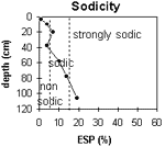 | The surface and upper subsoil is non-sodic becoming sodic at 50 cm and strongly sodicat 90 cm depth. |
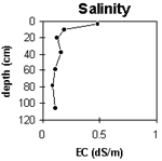 | The surface salinity rating is high. The subsoil rating is very low throughout. | 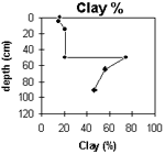 | The clay content increases abruptly at the A/B horizon interface and then decreases. |
Horizon | Horizon Depth (cm) | pH (water) | pH (CaCl2) | EC 1:5 | NaCl | Exchangeable Cations | |||
Ca | Mg | K | Na | ||||||
meq/100g | |||||||||
A1 | 0-5 | 5.5 | 4.9 | 0.48 | 0.05 | 4.2 | 1.9 | 1.1 | 0.2 |
A2 | 5-15 | 5.5 | 4.8 | 0.19 | 2 | 1.1 | 0.5 | 0.37 | |
A3 | 15-25 | 6.4 | 6.3 | 0.13 | 2.2 | 1.6 | 0.51 | 0.28 | |
B21 | 25-50 | 6.3 | 5.7 | 0.16 | 3.5 | 7.4 | 1.2 | 0.91 | |
B22 | 50-65 | 7.1 | 6.3 | 0.11 | 2.1 | 7.4 | 0.52 | 1.1 | |
B23 | 65-90 | 7.8 | 6.6 | 0.09 | 1.8 | 8.5 | 0.21 | 1.7 | |
B24 | 90-120 | 8 | 6.8 | 0.11 | 1.6 | 7.1 | 0.19 | 2 | |
Horizon | Horizon Depth (cm) | Exchangeable Aluminium mg/kg | Exchangeable Acidity meq/100g | Field Capacity pF2.5 | Wilting Point pF4.2 | Coarse Sand (0.2-2.0 mm) | Fine Sand (0.02-0.2 mm) | Silt (0.002-0.02 mm) | Clay (<0.002 mm) |
A1 | 0-5 | <10 | 12 | 11.7 | 24 | 38 | 15 | 16 | |
A2 | 5-15 | <10 | 6 | 6 | 29 | 39 | 15 | 15 | |
A3 | 15-25 | 7 | 30 | 36 | 13 | 21 | |||
B21 | 25-50 | <10 | 8.3 | 23.6 | 10 | 9 | 6 | 74 | |
B22 | 50-65 | 18.2 | 29 | 9 | 7 | 56 | |||
B23 | 65-90 | 16.2 | 15 | 27 | 12 | 46 | |||
B24 | 90-120 |
Whole Profile
- Plant Available Water Capacity (PAWC) is considered to be moderate (estimated at 105 mm) for this soil profile. This is based on an estimated effective rooting depth of 50 cm (i.e. surface soil and upper subsoil). The dense and coarsely structured deeper subsoil is likely to restrict rooting depth. A significant amount of the plant available water is estimated to be in the upper 25 cm of the subsoil (i.e. estimated 70 mm available water) compared to the upper subsoil (B21) horizon (estimated 35 mm available water). PAWC has been estimated using a model developed by Littleboy (1995) which uses analytical data for clay%, silt%, fine sand%, coarse sand % and wilting point.
- The surface soil is strongly acid. This indicates that aluminium and manganese toxicity could occur with shallow rooted species. However, the level of exchangeable aluminium measured for this pit site is quite low (<10 mg/kg), and unlikely to restrict the growth of aluminium sensitive species. Lime is often used to raise soil pH but it should be noted that a pH/aluminium test is best performed from samples taken across the paddock and bulked together. Other factors also need to be considered before lime is recommended e.g. pasture species grown, method of application, local trial responses, soil surface structure and likely cost/benefit.
- Manganese toxicity may also occur particularly in poorly drained situations, as waterlogging may bring manganese into solution.
- Deficiencies of molybdenum, phosphorus and potassium may occur in sandier strongly acid surface soils. Increasing soil pH by lime application should enable phosphorus (from superphosphate) and molybdenum to become more available. If lime is required, and pH is increased, then the availability of major nutrients should improve.
- The level of soluble salts in the surface is moderate and may restrict the growth of salt sensitive species. These levels may be unnaturally high due to the effects of the dry season (1996/97) and are likely to decline following heavy rainfall and/or irrigation.
- The nutrient holding capacity of the surface (A1) horizon is low (based on the sum of the exchangeable calcium, magnesium and potassium cations). Organic matter is important for enhancing soil fertility as well as water holding capacity and soil structural condition. Nitrogen levels are quite high at this site, reflecting the high organic matter levels.
- The upper subsoil is non-sodic and well structured (parting strongly to fine polyhedral shaped peds). Root and water movement will be relatively good compared to other more coarsely structured and sodic subsoils in the region.
- The deeper subsoil becomes coarsely structured and sodic which will result in restricted root and water movement at depth in this soil profile.