Victorian Resources Online (archived)
Archived content — This page contains material from the Victorian Resources Online (VRO) website. It is no longer maintained and is provided for reference only. This content is hosted by CeRDI and is not endorsed by Agriculture Victoria.

Sitemap

Environmental Monitoring Sites

Back to: North Central - Environmental Monitoring Sites

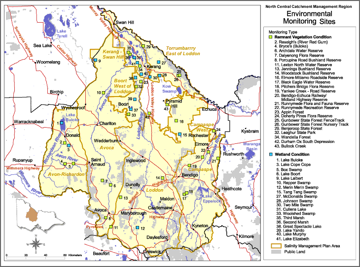
This is a clickable map. Click on EMS in legend for detailed information.

Environmental Monitoring Sites

Environmental monitoring sites
Remnant Vegetation Condition12. Merin Merin Swamp
2. Reseigh's (River Red Gum)24. Doherty Pines Flora Reserve15. Tang Tang Swamp
4. Bryce's (Buloke)25. Gunbower State Forest Fence Track27. McDonalds Swamp
6. Archdale Water Reserve28. Gunbower State Forest Nursery Track28. Johnson Swamp
7. Daleynong Flora Reserve29. Benjeroop State Forest30. Two Mile Swamp
8. Porcupine Road Bushland Reserve32. Leaghur State Park31. Cullens Lake
11. Lexton North Water Reserve34. Wandella Forest33. Woolshed Swamp
13. Jennings Bushland Reserve42. Durham Ox South Depression35. Third Marsh
14. Woodstock Bushland Reserve43. Bullock Creek36. Second Marsh
16. Elmore-Mitiamo Roadside Reserve38. Great Spectacle Lake
17. Black Eage Water ReserveWetland Condition39. Lake Yando
18. Pilchers Bridge Flors Reserve1. Lake Buloke40. Lake Murphy
19. Yankee Creek - Road Reserve3. Lake Cope Cope41. Lake Elizabeth
20. Bendigo-Echuca Railway/Midland Highway Reserve5. Box swamp
21. Runnymede Flora and Fauna Reserve6. Lake Boort
22. Runnymede Recreation Reserve9. Lake Lalbert
23. Appin Forest10 Repper Swamp