Victorian Resources Online (archived)
Soil/Landform Mapping Kaniva - Kaniva Mapsheet
To view the information PDF requires the use of a PDF reader. This can be installed for free from the Adobe website (external link).
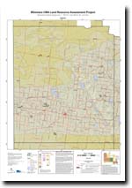 | Map of Kaniva - (T7125) (PDF 1.1MB) | Landform Units Map Unit descriptive names (PDF 109KB) |
| Soil Groups | |||
| 32 | 34 | 35 | 37 |
| Soil Pits | |||
| LSWW 7 LSWW 8 WIA 24 WIA 31 | WIA 5 WIA 6 WIA 9 | LS 8 LS 15 LS 28 | LS 3 LSWW 5 LSWW 9 |
| Geomorphic Units | ||||||
| 2.1.1 | 2.1.2 | 2.1.3 | 2.1.4 | 2.1.5 | 2.1.6 | 2.1.7 |
| 2.2.1 | 2.2.2 | 2.2.3 | 2.3.1 | 2.3.2 | 4.1.1 | 4.1.2 |
| 4.2.1 | 4.2.2 | 4.2.3 | 4.3 | 5.1.3 | 5.1.5 | 5.2.1 |
| 5.2.2 | 5.3.3 | 5.4 | 5.5.1 | 5.5.2 | 5.5.3 | 5.6 |
| 6.2.1 | ||||||