
| Corangamite Soil Health Strategy 2006-2012 |
| Home | Introduction | CSHS Report | Background Reports | Outputs/Maps | Projects | Community/Events | Contacts | Links | Photo Gallery |
|
|
| Introduction |
| This section is a synopsis of the Corangamite Soil Health Strategy 2006-2012. [Download brochure] (1.2 MB) | ||||
| Overview of the Strategy | ||||
| Objectives of the Strategy | ||||
| Partnerships and joint action to address the threats | ||||
| Priorities for investment | ||||
| Identifying assets, threats and investment priorities | ||||
| Targets and programs | ||||
| Overview of the Strategy | ||||
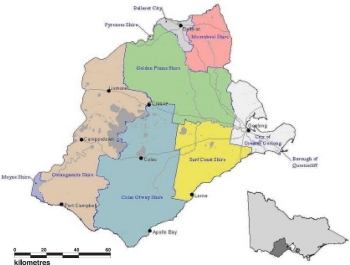
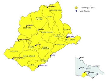
The Corangamite Soil Health Strategy aims to guide investment in a range of actions that will protect and enhance natural and built assets in the Corangamite region from a number of soil-based threats or threatening processes. The strategy identifies specific assets that should be protected or enhanced, the various threats, the asset managers and other stakeholders who have been involved in its development and will potentially be involved in its implementation.The Soil Health Strategy focuses on the identification and validation of priorities for investment to protect and enhance important natural and built assets in the Corangamite region. Importantly, these investment priorities are based on careful assessment of the relative value of assets and risks posed by threats.The Strategy also identifies the scale and time-frame for investment in soil health and the programs that should be employed to involve and create local participation across the Corangamite community. The Strategy also identifies the indicators and protocols that should be used to monitor the effectiveness of the investments, enabling progressive reassessment throughout its life. The Corangamite region extends over some 1.3 million hectares of south-west Victoria, and includes many high value and irreplaceable natural resources, including internationally recognised lakes and wetlands. The region is home to a human population of some 400,000; the social and commercial fabric of their lives is as varied as any other part of the country and ranges from extensive and diverse primary industries to important manufacturing and exporting enterprises. The Corangamite region includes part or all of nine municipalities; the Corangamite Catchment Management Authority (CMA) has delineated 15 landscape zones within its boundaries. |
|
Community consultation and actionIn the development of the strategy, many sectors of the Corangamite community were consulted. In some cases, self-evident needs and priorities for action could be and were identified, funding was arranged and work was initiated well before the finalisation of this document. Great encouragement for the future of the strategy may be taken from these initiatives and the ways they were established since they highlight a strong sense of ‘ownership’ of the soil health issue by various sectors of the local community.Services provided by the assets of the region are equally vital for the current and future wellbeing of the natural environment and the resident human population. The threats to these assets are real. Many are immediate; their effects have been and are currently being felt, seen and measured. Protection and enhancement of the assets through investment – which must be targeted because the task is so large – is a responsibility that cannot be denied. A critical issue for the strategy has been the development and application of a robust logic for determining the investment priorities. |
|
|
|
|
|
||||
Foundations and direction of the StrategyAs a regional document, the strategy links to Victorian and Australian government strategies and fits within the broader framework set by their foundations, logic and direction. The Corangamite Soil Health Strategy aims to dovetail into and (in as many respects as possible), work closely with the wider state and national strategies, gaining more effective natural resource management outcomes all round.The strategy takes a logical and objective approach to guiding investment based on definition of natural and built ‘assets’ that are at risk from various soil-based ‘threats’ – almost all of which arise as a result of disturbance of the natural environment through human activity in urban and rural development, recreational and other activities. Priorities for investment are identified through several key measures. These include Relative Asset Value, area under threat and the relative severity of the threat. A formula linking these measures provided “Relative Risk Values” for the threatening processes addressed by the strategy in each of the 15 landscape zones in the region. More than 140 ‘Relative Risk Values’ were developed from this process. From these, 20 priorities for investment have been identified with the highest ranking subjected to field and research-based validation. Details of the anticipated investment program, characterised by Resource Condition Targets may be found in the Strategy. |

|
Top of Page |
| Objectives of the Strategy | ||||
|
The Soil Health Strategy aims to guide investment in a range of actions that will protect
and enhance natural and built assets in the Corangamite region from a number of soilbased
threats or threatening processes. For these aims to be achieved, objectives must be
identified and specific investments must be made. The principal objectives of the Strategy are:
|
Detailed profiles of each landscape zone have been assembled. These are found in Appendix C of the Strategy. |
|||
| Partnerships and joint action to address the threats | ||||
|
Perhaps most importantly of all, the Strategy recognises the pivotal role of partnerships
in the effective implementation of the various actions. A diverse range of public and private sector asset managers and other stakeholders influence soil management practices (and therefore soil health) in the region. These same individuals and entities also make significant inputs to other aspects of natural resource management. Their involvement in partnership approaches to soil health actions is therefore essential. Well targeted actions have been developed to address the 20 highest validated priorities for investment. These are detailed in Section 5 of the Strategy. An important task now is the communication of these priorities and the development of partnership-based projects and funding applications. |
Four ‘Principles of Implementation’ are included in the Strategy:
|
|||
Top of Page |
||||
| Priorities for Investment | ||||
| “Validated priorities for investment” – the highest Relative Risk Values after field validation provide the key guidance for investment. Shown here are the 20 highest ranking priorities for investment. The Strategy team identified more than 140 ranked locations where there are clear threats to assets. These are listed in full, in Appendix B - Table B4 of the Strategy document. | ||||
| Final Rank | Landscape Zone | Threat | Known Assets At Risk from priority Threat | |
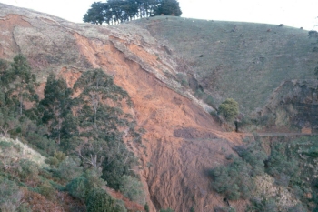
| 1 | Gellibrand | Landslides | Lower Gellibrand River, Johanna River, Stafford Creek and Kennedy Creek. Princetown and Simpson River. | |
| 2 | Lismore | Secondary Salinity | Lake Martin | |
| 3 | Woady Yaloak | Gully/tunnel Erosion | Mount Misery Creek, Moonlight Creek and Woady Yaloak River. High to very high native vegetation conservation potential, mostly along waterways from Mount Mercer to Pittong. Some rural roads north of the Rokewood-Skipton Road. |
|
| 4 | Woady Yaloak | Sheet/ rill Erosion | ||
| 5 | Stony Rises | Secondary Salinity | Lake Martin and the upper reaches of Barongarook Creek. | |
| 6 | Otway Coast | Landslides | Great Ocean Road, Turtons Track and Wild Dog Road. Wild Dog Creek, Barham River and Smythe Creek. |
|
| 7 | Curdies | Landslides | Scotts Creek, Curdies River, Cowley Creek and Port Campbell Creek. Coastal recreational areas. |
|
| 8 | Moorabool | Sheet/ rill Erosion | Eclipse Creek, Tea Tree Creek, Anakie Creek and Deadman Gully.
Central Highlands/Barwon Water managed Proclaimed Water Reservoir. |
|
| 9 | Moorabool | Gully/tunnel Erosion | ||
| 10 | Woady Yaloak | Secondary Salinity | Woady Yaloak River, Lake Corangamite. | |
| 11 | Murdeduke | Secondary Salinity | Native vegetation of very high to high conservation significance potential. Wetlands along Mia Mia Creek, Warrambine Creek (north of Wingeel Swamp), and in groups of small wetlands east of Eurack (near Hesse Rd). |
|
| 12 | Leigh | Gully/tunnel Erosion | Woodbourne Creek, Lower Williamson Creek, Yarrowee River and Leigh River. |
|
| 13 | Leigh | Sheet/rill Erosion | ||
| 14 | Upper Barwon | Landslides | Roads along the flanks of the Otway Ranges. Waterways along the western flanks of the Barwon River Valley, south of Birregurra. |
|
| 15 | Aire | Landslides | Aire River and the West Branch of the Ford River. | |
| 16 | Upper Barwon | Sheet/rill Erosion | Wormbete Creek, Yan Yan Gurt Creek and Barwon River. | |
| 17 | Upper Barwon | Gully/tunnel Erosion | ||
| 18 | Thompsons | Sheet/rill Erosion | Thompson Creek and Spring Creek. | |
| 19 | Bellarine | Acid Sulphate Soils | Point Henry environments. | |
| 20 | Thompsons | Acid Sulphate Soils | Breamlea Wetlands and Lower Thompson Creek. |
| Resource Condition and Management Action Targets have been developed for the strategy to help monitor the effectiveness of implementation. These Targets will be improved as further research is completed. The cost of addressing the priorities in the Corangamite Soil Health Strategy in the next five years of implementation is approximately $5,500,000. However, this figure may change significantly, as new information becomes available. | ||||
Top of Page |
| Identifying assets, threats and investment priorities | ||||
|
There are real, active and latent soil-related threats to the natural and built assets of the
Corangamite region. These are identified, linked and ranked via a logical and objective framework
in this Strategy. Validated priorities for investment are identified with specific action plans,
targets and monitoring activities. Primary asset classes are identified in the Corangamite Soil Health Strategy:
There are twelve key threats: landslides, water erosion (sheet/rill and gully/tunnel erosion), acid sulphate soils,secondary salinity, waterlogging, soil structure decline, wind erosion, soil nutrient decline, soil acidification, soil contamination, soil organic carbon decline and soil biota decline. Some of these act locally (virtually in-situ with the asset),while others may be seen as ‘mobile’ in that they have the potential to impact other, off-site assets. Relative Risk Values combine assessments of Relative Asset Value and Risks that are posed by the threats. These values have been assembled after extensive interpretation of various forms of satellite derived imagery and validated from onground field inspection. |
Five of the 12 threats were noted in the 20 highest Relative Risk Values: landslides, sheet/rill
erosion, gully/tunnel erosion, secondary salinity and acid sulphate soils. All five impact on
public assets and have the potential to impact all primary and secondary asset classes.
Assessment of Relative Risk Values by landscape zone to determine the ranking of the threats
against each other, (i.e. the aggregate values across the 15 landscape zones) showed that secondary
salinity had the highest aggregate Relative Risk Value, mostly because secondary salinity is relatively
widespread and often interacts with large areas of agricultural production and high value biodiversity
areas. It also has the potential to impact on water quality, built infrastructure and cultural heritage
sites. Landslides had the second highest aggregate Relative Risk Value in the region and also have the potential to impact on all asset classes. Landslides have the highest Relative Severity Value, because they are capable of severely impacting invaluable and irreplaceable natural assets, destroying buildings and other built infrastructure and taking human life. Water erosion, (sheet/rill and gully/tunnel) has the capacity to impact on all asset classes. These types of soil erosion pose greatest risk to water quality and agricultural production. Acid sulphate soils (ASS) had one of the highest aggregate risk values. These soils were often found in wetlands. Acid sulphate soils have the potential to impact on all asset classes with potentially catastrophic results. Soil structure decline, waterlogging, nutrient decline and soil acidification had lower Relative Risk Values because they solely impact on agricultural production and not high value public assets. Wind erosion potentially causes an impact to a range of assets. However, the likelihood of wind erosion events is relatively low compared with other threats to soil health in the region and therefore had a lower Relative Risk Value. |
Top of Page |
| Targets and programs | ||||
|
The Corangamite Regional Catchment Strategy, individual sub-strategies and action plans are
required to comply with the National Framework for Natural Resource Management Standards and Targets. The National Framework requires three tiers of targets to be set: aspirational targets, resource condition targets and management action targets. The aspirational target is ‘Bring about an improvement in the health and protection of soil resources and regional assets through positive processes and partnerships that allow individuals, communities, and organisations to sustainably manage their soils.’ The Resource Condition Targets are:- |
Management Action Targets are listed in the Strategy,
Section 6
. The Strategy development
team and the Authority have recognised for some time that the MATs listed in the Strategy
lack specificity. This is unavoidable at present because research work to more closely define
various resource conditions and the trends of various threats is not due for completion until July 2007. A closer understanding of appropriate MATs for the Soil Health Strategy will follow the completion of this work. When these more specific MATs are known, they will become additions to the Strategy, in common with other additions and amendments that are made in the light of new knowledge. |
|||
| Resource Condition | Target | |
| 1: All new urban or infrastructure developments in priority landscape zones will be planned and designed to reduce landslide risks. | 2011-2012 | |
| 2: No net gain in area affected by sheet or rill erosion in priority landscape zones from 2005 erosion levels. | 2011-2012 | |
| 3: No net gain in area affected by gully or tunnel erosion in priority landscape zones from 2005 erosion levels. | 2011-2012 | |
| 4: No potential acid sulphate soils will be disturbed and become acid sulphate soils in the Corangamite region. | 2008-2012 | |
| 5: In conjunction with the Corangamite Salinity Action Plan, no net gain in area affected by secondary salinity in priority landscape zones from 2005 salinity levels. | 2010-2012 |
Top of Page |
|
|
| Corangamite CMA Home | Acknowledgement | Disclaimer |

|
|
Page Updated: November 2007 |