Victorian Resources Online (archived)
Archived content — This page contains material from the Victorian Resources Online (VRO) website. It is no longer maintained and is provided for reference only. This content is hosted by CeRDI and is not endorsed by Agriculture Victoria.

Sitemap

Bairnsdale Mapsheet

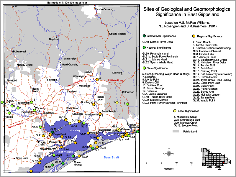
Back to: East Gippsland Sites of Geological and Geomorpholigical Significance

This is a clickable map. Click on site name in legend for detailed information

[Bairnsdale Mapsheet

sites of Geological and Geomorphological Significance - Bairnsdale
International SignificanceGL11 (8422) Slaughterhouse Creek
GL19 (8422) Mitchell River DeltaGL12 (8422) Nicholson River Delta
GL14 (8422) Tambo Bluff
National SignificanceGL15 (8422) Point Scott - Raymond Island
GL30 (8422) Rotomah IslandGL16 (8422) Shaving Point and floor of Lake King
GL31 Boole Boole Peninsula/Jubilee HeadGL17 (8422) Salt Lake (Taylors Swamp)
GL32 Sperm Whale HeadGL18 (8422) Purran Corner
GL21 (8422) Tyers Creek Road Cutting
State SignificanceGL22 (8422) Eagle Point Bluff
8422-5 Congulmerang - Walpa Road CuttingGL24 (8422) Butler Point
8422-7 SkinnersGL25 (8422) Point Fullarton
8422-8 Myrtle PointGL26 (8422) Bunga Arm
8422-9 Dreiers CliffGL27 (8422) Mullacky Lagoon ("Moss Ball" Lake)
8422-10 Soldiers RoadGL36 (8422) Tannin Point
8422-11 Pound SwampGL37 (8422) Wattle Point
8422-12 Bellevue
GL4 (8522) Cuspate Forelands at Lakes EntranceLocal Significance
GL10 (8422) Tambo River Delta8422-1 Mississippi Creek
GL20 (8422) McLeod MorassGL8 (8422) Nyerimalang Bluff
GL23 (8422) Point Turner - Banksia PeninsulaGL9 (8422) Maringa Creek
GL13 (8422) Gravel Ridges on Lake King Shoreline - Broome Point
Regional Significance
8422-2 Swan Rad Road Cutting
8422-3 Tambo River Cliffs
8422-4 Bruthen - Buchan Road Cutting
GL5/6 (8522) Hopetoun Channel, Hidden Lake
GL7 (8522) Jemmys Point