Victorian Resources Online (archived)
Archived content — This page contains material from the Victorian Resources Online (VRO) website. It is no longer maintained and is provided for reference only. This content is hosted by CeRDI and is not endorsed by Agriculture Victoria.
Sitemap
Traralgon Soils
Back to: West Gippsland - Traralgon Mapsheet
This is a clickable map. Click on Soil/Landform Unit for detailed information
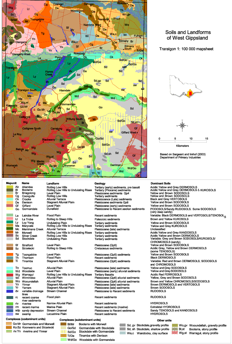
| Traralgon soils |
| Ab - Alambie | Bl - Boolarra | Br - Briagalong | Cg - Coongulla |
| Ck - Crooke | De - Denison | Gf - Giffard | Go - Gormandale |
| La - Latrobe River | Lt - La Trobe | Ly - Loy Yang | Ma - Maryvale |
| Mc - Merrimans Creek | Mr - Morwell | Sc - Silver Creek | Sd - Stockdale |
| Sf - Stratford | Sz - Strzelecki | Tg - Toongabbie | Th - Thomson |
| Ti - Tinamba | To - Toomuc | Wd - Woodside | Wg - Warragul |
| Wi - Winnindoo | Wo - Wooundellah | Yn - Yinnar | Yr - Yarram |
| dv - variable drainage lines | rc - recent coarse river sediments | riv - riverine | sdp - sandy depression |
| sw - swamp | Go:Mr - Gormandale and Morwell | Ko:Sz - Koonwarra and Stzelecki | riv:Yin - riverine and Yinnar |
| Bl/Mr - Boolarra with Morwell | Go/Sd - Gormandale with Stockdale | Sd/Go - Stockdale with Gormandale | Ti/De - Tinamba with Denison |
| Wd/Go - Woodside with Gormandale | Sd, gv - Stockdale, gravelly profile | Sd, sh - Stockdale, shallow profile | Wa, c - Wandocka, clay surface |
| Wo, gv - Wooundellah, gravelly profile | Bl, st - Boolarra, stony profile | Wg, st - Warragul, stony profile | |