Erosion and Landslide Resources in the
CCMA Region
Home | Introduction |
Definitions | User Guide | Maps
& Reports | Disclaimer
Introduction
Background
Summary of Current Study Findings - Erosion and Landslide Occurrences in the CCMA Region
Summary of Current Study Findings- Erosion and Landslide Occurrences in the CCMA Region Erosion can be found throughout the entire Corangamite Catchment Management Authority (CCMA) region. The processes of land degradation have been persistent throughout geological time and continue to be active although they are generally episodic in nature. A diverse range of landscapes and soil units exist within the CCMA region and when combined with highly variable climatic conditions across the region, resulting in annual rainfall ranging from 430 mm to in excess of 1250 mm, almost all types and forms of erosion are possible. The main processes of land degradation within the CCMA include:
|
The susceptibility of the Corangamite landscapes to these processes has been investigated in a number of studies over the years and includes investigations carried out by the former Soil Conservation Authority and subsequent government bodies. Early studies including those conducted by the Geological Survey of Victoria focused on mapping occurrences of landslides throughout the region. The Corangamite Land Resource Assessment (LRA) study completed by the Department of Primary Industries (DPI) in 2003, empirically assigned ratings to landform units to provide an assessment of the susceptibility of land degradation processes within the region. Later studies completed by the University of Ballarat and the CCMA began the process of mapping and capturing incidences of landslide and erosion within the CCMA’s boundary. These studies established a region-wide database detailing the results of mapping carried out from high resolution ortho-corrected aerial photographs. This work has since been extended by the CCMA to include new data sources and further aerial photo interpretation. |
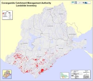
As a result over 10,600 incidences of erosion and landslides have been mapped throughout the CCMA region and some of the outlaying regions of municipalities within the region. Major areas of landslide susceptibility and activity within the CCMA include the northern coast of the Bellarine Peninsula, The Otway Ranges and coast, the dissected plains of the Heytesbury Region and the flanks of the major river valleys including the Barwon, Moorabool and Leigh Rivers. Erosion distribution is varied and is largely dependent on hazard type. The vast majority of gully erosion occurs in the three catchments in the north of the CCMA – the Woady Yaloak River catchment, the Leigh River catchment and the Moorabool River catchment – with the worst affected areas around Cape Clear, Illabarook, Bamganie and Morrisons. Sheet and rill erosion is more widespread, with the greatest number of sites mapped in the Moorabool River catchment followed by the Woady Yaloak River catchment and the Leigh River catchment. Rokewood Junction, Meredith, Anakie, and the You Yangs ranges are areas where sheet erosion is most conspicuous. Whilst the capture and collation of information and data is ongoing, the current number of mapped occurrences (as of April 2007) of erosion and landslide by municipality is shown in the following table: |
Municipality | Gully and Streambank Erosion | Sheet and Rill Erosion | Landslides |
City of Ballarat | 93 | 228 | 20 |
City of Geelong | 178 | 288 | 117 |
Colac Otway | 153 | 139 | 3189 |
Corangamite | 49 | 27 | 931 |
Golden Plains | 1603 | 777 | 48 |
Moorabool | 709 | 1125 | 379 |
Surf Coast | 128 | 119 | 224 |
Other shires adjacent to the CCMA region | 11 | 32 | 36 |
Totals | 2924 | 2735 | 4944 |
Overall Total of Erosion and Landslide Features=10603 |
It must be noted that despite the considerable work to date this inventory must still be considered to be incomplete. Other data sources are known to exist but have yet to be accessed. In addition limitations with the quality and scale of aerial photos mean many smaller hazards are incapable of being captured through this method. Not withstanding these limitations, the current study has significantly increased our knowledge and understanding of erosion and landslide processes throughout the CCMA region. It is only from such information that informed decision making and improved land management can be developed and implemented. |
Top of Page
Produced by AS Miner Geotechnical
Copyright 2007