Background and Aims
Comprehensive Landslide Method
Application for Intended Use
Background and Aims
The knowledge of the distribution and spatial extent of erosion and landslide features throughout the
CCMA region is considered a critical element of the current study. The method of capture for such data varies significantly and may include field-based observations and measurements or mapping from remote data such as aerial photographs, radar or satellite imagery.
Much of the recent data capture for the current erosion and landslide inventory was undertaken using non stereo interpretation of high resolution ortho-corrected photo mosaics of the CCMA region. However the earlier work for landslide recognition was carried out
by the Geological Survey of Victoria (GSV) using stereo aerial photo interpretation using high quality 1:16,000 black and white aerial photos from 1946.
One of the aims of the current 2006/2007 CSHS project included repeating the original landslide mapping exercise undertaken by the GSV in 1980. As the initial data from this study only represented landslides by their headscarps, it was hoped to enhance that data set by representing all landslides by a closed polygon reflecting not only the headscarp but the overall mass or body of the slide as well. It was also hoped to extend the API method to the identification of erosion features.
The work was undertaken using the skills and experience of Ian Roberts from Earth Resource Analysis under the supervision of A.S. Miner Geotechnical.
Comprehensive Landslide Method
As discussed, one of the major limitations with the early work undertaken by the GSV was that landslides were generally only represented by the rear headscarp. This is thought to have been a result of the complexity of the disturbed landscape and the uncertainty associated with the actual extent of any displaced mass.
As such, one of the initial aims of the methodology was to deliver a spatial representation of the landslides that included the rear headscarp, the extent of the scarp face and the main body of the slide (alternatively known as the displaced slide material).
Information on the type, age and activity of the landslide was also seen to be a desirable part of the proposed data interpretation and capture method.
A first pass at an API mapping pathway established four key fields of data: landslide
age, (class), mapping reliability, landslide activity and landslide type.
Early trialling of the method highlighted the difficulty of isolating only the landslide types within the landscape and it was soon apparent that a better approach would be to employ a holistic geomorphological approach to landscape recognition. As a result, the API pathway was modified and redesigned to accommodate the following fields:
| • | Geomorphic Feature (including landslide type and adjacent features such as ridges, un-failed interfluvial slopes, floodplains, river terraces and valley floors). |
| • | Landside age (origin) |
| • | Mapping reliability |
| • | Landslide Activity |
 |
 |
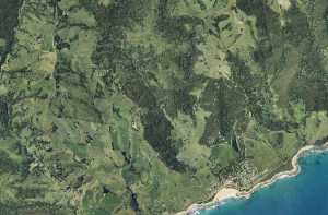
| Aerial photo of Skenes
Creek - 2004 (Click for larger image) |
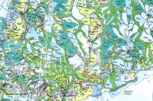
API for the same area
(Roberts 2006) (Click for larger image) |
The reorganization of the API mapping fields afforded a more logical approach to data capture and allowed the assessor to work from ridge to drainage lines in a geomorphic sequence more aligned to the natural process of landscape evolution.
Other features such as springs and stream pattern were added at stages of the development of the method. Stream pattern delineation in particular proved to be a vital piece of the mapping process as it allowed for much greater accuracy in the process
of transferring details from marked up hard copy photos to the GIS framework. Additional features within each category were also added to the process as more and more variations of themes were noted in the landscape by the assessor.
Application for Intended
Use
The purpose of the aerial photo interpretation studies is to provide detailed information on the location and extent of landslides within the CCMA region. The process was meant to compliment the earlier work by the GSV. While all care has been taken to record data as accurately as possible, the data custodians do not guarantee that the data is accurate, up to date, complete or suitable for any purpose. The data custodians disclaim all other liability for all loss, damage, cost or expense incurred by any person as a result of relying on the data.