Background and Aims
Selection of Sites and Discussion
Application for Intended Use
Background and Aims
Information on the spatial distribution and extent of erosion and landslides is a critical part in understanding these processes within the CCMA. Similarly additional information on the rate at which these potential hazards occur is also critical in assessing the significance of such processes. However, information on the nature and severity of the impact that these hazards cause and the significance of the assets which are impacted, is also equally important.
The current 2006/2007 program for the Corangamite Soil Health Strategy (CSHS) recognised the need for such information and a series of case studies were commissioned to provide specific data on the nature, extent and impact of erosion and landslides at various important locations throughout the CCMA region.
The aim of the case studies was to provide more detailed information on the extent of the hazard, how it was initially assessed and what remedial actions were either undertaken or proposed. In addition the case studies review what assets were effected, how severe the impact was and what consequences and financial costs were associated with effected assets.
 |
 |
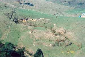
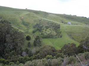
| Barham River before remediation | Barham River after remediation |
Selection of Sites and Discussion
Sites were chosen to correspond with locations and sites established as priority target areas during the early stages of the 2006/2007 CSHS program. Sites containing important assets and known incidences of landslide and erosion were initially short listed.
A series of site inspections and, where possible, interviews with land owners were then carried out to obtain information about both the hazard and the impact on the assets effected. Whilst some sites were not able to be completed due to insufficient information being available from the major stakeholder, valuable information was assembled for a number of sites.
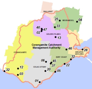
| Case study documents can be viewed by clicking on the map below. Case study ID is labeled on the map. | |
 |
|
A full list of sites initially chosen and the currents status of progress is listed in the following table:
(Documents can also be accessed by clicking on the ID)
| ID | Type | Location | Status |
| 356.3/01 | Landslide | Barham Valley Road, Apollo Bay | Completed |
| 356.3/02 | Gully | Rokewood-Skipton Road, Pitfield | Incomplete |
| 356.3/03 | Landslide | Princetown-Simpson Rd Princetown (Bouwman) | Completed |
| 356.3/04 | Landslide | Western Freeway Bacchus Marsh | Completed |
| 356.3/05 | Landslide | Great Ocean Road (Windy Point) | Completed |
| 356.3/06 | Landslide | Yeodene-Birregurra Road, Birregurra (Phillips) | Completed |
| 356.3/07 | Tunnel Erosion | Separation Creek | Not Started |
| 356.3/08 | Tunnel Erosion | Kennett River | Not Started |
| 356.3/09 | Tunnel Erosion | Deans Marsh-Lorne Rd, Deans Marsh | Not Started |
| 356.3/10 | Landslide | Great Ocean Rd Wongarra | Not Started |
| 356.3/11 | Landslide | Wild Dog Ck Rd Apollo Bay (Big Slide) | Not Started |
| 356.3/12 | Landslide | Guys Rd The Heytesbury (Pau's) | Incomplete |
| 356.3/13 | Gully Erosion | Robbies Rd Shelford (Meeke's) | Completed |
| 356.3/14 | Streambank Erosion | Jetty Rd, Clifton Springs | Not Started |
| 356.3/15 | Landslide | Great Ocean Road Easternview (Clarke's) | Not Started |
| 356.3/16 | Streambank Erosion | Golf Course, Clifton Springs | Not Started |
| 356.3/17 | Landslide | The Dungeon Aire River | Not Started |
| 356.3/18 | Landslide | Great Ocean Rd (Cumberland River) | Not Started |
| 356.3/19 | Landslide | Great Ocean Rd (Browns Creek) | Not Started |
| 356.3/20 | Landslide | Lake Elizabeth, Forrest | Completed |
| 356.3/21 | Landslide | Wye River, (Morley Ave) | Not Started |
| 356.3/22 | Landslide | Melba Parade, Anglesea | Incomplete |
| 356.3/23 | Landslide | Dorman St, Lorne | Not Started |
| 356.3/24 | Landslide | Sunnyside Rd, Wongarra | Not Started |
| 356.3/25 | Landslide | Lal Lal Reserve | Completed |
| 356.3/26 | Landslide | Bird Rock, Jan Juc | Not Started |
| 356.3/27 | Landslide | Moorabool River, Sheoaks | Not Started |
| 356.3/28 | Landslide | The Dell, Clifton Springs | Completed |
| 356.3/29 | Landslide | Ocean Grove Lookout | Not Started |
| 356.3/30 | Landslide | Seymour Crescent, Apollo Bay | Not Started |
| 356.3/31 | Landslide | Turtonís Track, Beech Forrest | Not Started |
| 356.3/32 | Landslide | Great Ocean Road (General) | Completed |
| 356.3/33 | Erosion | Horsehill West Road Elaine (Gallows) | Incomplete |
| 356.3/34 | Erosion | Tall Tree Road, Meredith | Incomplete |
| 356.3/35 | Erosion | Magpie, Ballarat | Not Started |
| 356.3/36 | Erosion | Fisken Rd, Mt Helen | Not Started |
| 356.3/37 | Erosion | Pennyroyal (Smiths) | Completed |
| 356.3/38 | Landslide | The Bluff, Barwon Heads | Not Started |
| 356.3/39 | Erosion | Coronae Drive, Clifton Springs | Not Started |
| 356.3/40 | Erosion | Misery Moonlight (Lex Hadler's) | Completed |
| 356.3/41 | Erosion | Spring Creek, Torquay | Not Started |
| 356.3/42 | Erosion | Canadian Gully, Ballarat | Not Started |
| 356.3/43 | Landslide | Black Hill, Ballarat | Not Started |
| 356.3/44 | Landslide | Glenmore Road, Parwan Valley | Not Started |
| 356.3/45 | Erosion | Pennyroyal (Clissold's) | Completed |
| 356.3/46 | Erosion | Barrabool Hills | Completed |
| 356.3/47 | Erosion | Bulldog Reserve, Illabarook | Completed |
| It is envisaged that further case studies on the list above will be completed in ongoing programs of the CSHS in addition to other existing examples which can be added to this overall inventory of impact. |
Application for Intended Use
The purpose of these case studies is to interpret the location and extent of erosion and/or landslides and to document impact to significant assets. While all care has been taken to record data as accurately as possible, the data custodians do not guarantee that the data is accurate, up to date, complete or suitable for any purpose. The data custodians disclaim all other liability for all loss, damage, cost or expense incurred by any person as a result of relying on the data.