Victorian Resources Online (archived)
Soil/Landform Mapping Beaufort - Beaufort Mapsheet
To view the information PDF requires the use of a PDF reader. This can be installed for free from the Adobe website (external link).
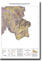 | Map of Beaufort - (T7523) (PDF 1.1MB) | Landform Units Map Unit descriptive names (PDF 109KB) |
| Soil/Landform Units | ||
| Ararat Hills | Concongella Hills | Drung Alluvial Plain |
| Elmhurst Footslopes | Glenorchy 1 | Glenorchy 2 |
| Great Western 2 | Great Western 3 | Howard Creek 1 |
| Howard Creek 2 | Howard Creek 3 | Joel South Hills |
| Kanya Hills | Landsborough 2 | Langi Ghiran Ranges |
| Langi Slopes 1 | Langi Slopes 2 | Mt Cole Creek |
| Navarre 1 | Navarre 2 | Navarre 3 |
| Pyrenees Mountains | Rhymney Hills | Six-Seven Miles Creeks |
| Surridge 2 | ||
| Soil Groups | ||||
| 2 | 6 | 7 | 11 | 12 |
| Soil Pits | ||||
| ALRA 81 DOAGW 22 WLRA 141 WLRA 143 | WLRA 141 WLRA 142 WLRA 143 | WLRA 138 | WLRA 63 WLRA 66 | DOAGW 12 WLRA 144 WLRA 145 WLRA 148 |
| Geomorphic Units | ||||||
| 2.1.1 | 2.1.2 | 2.1.3 | 2.1.4 | 2.1.5 | 2.1.6 | 2.1.7 |
| 2.2.1 | 2.2.2 | 2.2.3 | 2.3.1 | 2.3.2 | 4.1.1 | 4.1.2 |
| 4.2.1 | 4.2.2 | 4.2.3 | 4.3 | 5.1.3 | 5.1.5 | 5.2.1 |
| 5.2.2 | 5.3.3 | 5.4 | 5.5.1 | 5.5.2 | 5.5.3 | 5.6 |
| 6.2.1 | ||||||