Victorian Resources Online (archived)
Archived content — This page contains material from the Victorian Resources Online (VRO) website. It is no longer maintained and is provided for reference only. This content is hosted by CeRDI and is not endorsed by Agriculture Victoria.

Sitemap

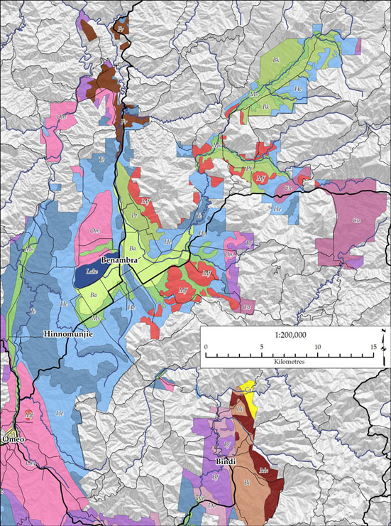
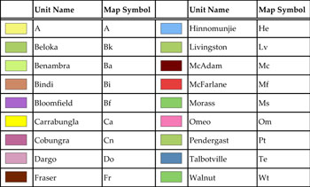
Soils - landform map units of the Benambra region

Back to: Soils and landforms of the Omeo/Benambra and Tambo Valley region

Soil-landform units of the Benambra region (PDF - 869KB) The high resolution PDF file provided on this page can be viewed using the free Adobe PDF reader and this software can be installed from the Adobe website (external link). This PDF is provided with a high level of detail and with the intent that it should be printed at a high resolution.

Soils and landforms of the Omeo/Benambra and Tambo Valley region - soil - landform mpa units of the Benambra regionSoils and landforms of the Omeo/Benambra and Tambo Valley region - map key Map unit A Beloka Benambra Bindi Bloomfield Carrabungla Cobungra Dargo Hinnomunjie Livingston McAdam McFarlane Morass Omeo Pendergast Talbotville Walnut Fraser

Soil - landform units of the Omeo region

Map Unit A (A)Beloka (Bk)Benambra (Ba)Bindi (Bi)Bloomfield (Bf)
Carrabungla (Ca)Cobungra (Cn)Dargo (Do)Fraser (Fr)Hinnomunjie (He)
Livingston (Lv)McAdam (Mc)McFarlane (Mf)Morass (Ms)Omeo (Om)
Pendergast (Pt)Talbotville (Te)Walnut (Wt)