Victorian Resources Online (archived)
Landscape Units
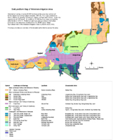 Soils/Landforms of the Wimmera Irrigation Area | Landscape and Soil Relationships in the Wimmera Irrigation Area
| |
Characteristic Features of Landscape Mapping Units
Landscape and Mapping Unit Symbol | Probable Original Vegetation | Characteristic Soil Type | Landform General Description |
| Gently Undulating Plains (GP) | Buloke, Spear and Wallaby grass | Kalkee clay | Undulating plains with long gentle slopes and occasional slight rises. |
| Moderately Undulating Plains (MP) | Buloke | Longerenong clay, Drung sandy clay loam | Moderately undulating plains. |
| Eroded Ridge Crest (EC) | Buloke | Kalkee clay, Drung sandy clay loam | Undulating plains, occasional sharp rises with associated depressions. |
| Eroded Plain (EP) | Buloke | Drung sandy clay loam, Longerenong clay, Kalkee clay | Level to gently undulating plains |
| Eroded Slope (ES) | Buloke | Drung sandy clay loam, Longerenong clay, Kalkee clay | Gentle to moderate slopes. |
| Flood Plain (FP) | Grey Box | Horsham clay, Murtoa clay, Drung sandy clay loam | Level areas, occasional slight rises. |
| Level Plain (LP) | Spear and Wallaby grass | Kalkee clay | Level areas. |
| High Plains (HP) | Spear and Wallaby grass, Grey Box, Box, Buloke and Yellow Gum | Type E, Drung sandy clay loam, Horsham clay and Murtoa clay | Level, gently undulating in some areas, typically sloping down to the Flood Plain unit. |
| Lake and Lunette (single unit) (LS) Lake and Lunette (clustered unit) (LC) | Black Box on lake beds, Buloke and occasionally grasslands on lunettes | Bungallally clay on lake beds, Drung sandy clay loam and Drung sandy loam on lunettes | Lake beds or depressions with rises, crescent shaped in plan, on eastern sides. |
| Dune and Swale (DS) | Brown Stringbark, Apple Box, Yellow Box and Yellow Gum with heath understorey | Quantong sand, Haven sandy loam, Haven sandy clay loam, Norton Sandy Clay | Sand sheets, sand dunes, typically east-west, interdune corridors. |
| Sand Plain (SP) | Box, Buloke and Yellow Gum Tall Woodland | Haven sandy loam, Quantong sand shallow phase and Murtoa clay | Level to gently sloping plain. |
| Prior Stream Flood Plain (PS) | (Grey) Box, Buloke and Yellow Gum, Spear and Wallaby grass | Murtoa clay, various red and grey soil complexes | Level plain, occasional slight rises, shallow stream courses and associated levees. |
| Black Box Flats (BB) | Black Box | Murtoa clay, Horsham clay | Level areas or narrow valley flats. |
| River Frontage (RF) | Black Box | Murtoa clay, various unclassified soils, Norton Sandy Clay | Generally narrow low lying often dissected areas bordering the Wimmera River. |
| Valley Floor (VF) | Black Box | Unclassified soils | A low lying area at the southern end of the Yarriambiack Creek. |