Introduction
Mapping Processes, Susceptibility, Hazard and Risk
Introduction
The Corangamite Soil Health Strategy (CSHS) has adopted a relative risk-to-asset based approach to help identify priority areas where different soil threatening processes pose the greatest risk to highly valued assets.
In order to facilitate this process, information regarding the extent and distribution of threats (or hazards) such as erosion and landslides is needed as well as information on assets. The interaction between threats and assets is then undertaken using GIS methods and risk is estimated based on the severity and significance of the impact on the asset.
The process of assembling information needs to be essentially linear with each progressive stage completed before the next one begins. The following section describes the process of information gathering and modelling which must be completed to allow a meaningful asset based risk approach for soil threatening hazards.
Mapping Processes, Susceptibility, Hazard and Risk
Information must be systematically assembled to allow this risk-based approach to be undertaken and the compilation of the inventory maps and the susceptibility maps detailed on this erosion and landslide resource are key elements in this process.
The key steps in any risk based approach are as follows:
| • | Collation of information on various factors which may have an influence on the presence and/or the initiation of the hazard under study. Such factors are sometimes described as preparatory casual factors and triggering causal factors (factor mapping) |  |
| • | Assembly of information on the hazard under study (data inventory) | |
| • | Collation of this information into spatial coordinates (inventory mapping) | |
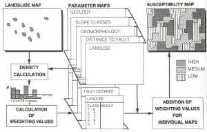
| • | Combination of the preparatory and triggering factors with the known distribution of the hazard to establish areas of actual and possible or likely occurrence. This is also known as susceptibility (susceptibility mapping) | Use of GIS
for bivariate statistical analysis (Click for larger image) |
The CSHS program has now progressed to the point where detailed susceptibility modelling has been completed which shows areas of high, medium and low susceptibility for landslides, gully and sheet erosion.
The next stages of an overall assessment process for the entire CCMA region would involve hazard analysis and then ultimately risk assessment. In order to facilitate hazard analysis information is required on the frequency or likelihood of the hazard. As such, trend mapping which looks at the rate of occurrence over a set period of time has been commenced as part of the 2006/2007 program.
Another important part of the risk based approach is the determination of how severe an asset is impacted and how important or significant the impact is. This is usually termed consequence analysis. In order to assist with a better understanding of consequence, a series of case studies have been undertaken which provide information on the hazard and the nature of the impact. This impact is described in financial costs where possible and includes the costs of investigations and remedial works undertaken to address the effects of the hazard.
Ultimately a risk assessment for any asset can be undertaken once sufficient information is available on the nature of the hazard (assisted through inventory mapping), the likelihood of the hazard (insight gained through the historical inventory and trend mapping) and the consequence resulting from the hazard (understanding obtained from case studies). The current CSHS program will assist in providing such information to allow better investment to address the impacts from soil threatening hazards on valued assets.