Erosion  and Landslide Resources in the CCMA Region   
 
HomeIntroduction DefinitionsUser GuideMaps & ReportsDisclaimer        


Trend Mapping and Analysis

Background and Aims

Target Areas and Selection of Sites
Summary of Results
Application for Intended Use
Landslide Trend Maps
Erosion Trend Maps

Background and Aims

The knowledge of the distribution and spatial extent of erosion and landslide features throughout the CCAM region is considered a critical element of the current study. However information on the rate of occurrence of these hazards was identified under the 2006/2007 CSHS program as a significant knowledge gap in the understanding of such processes within the CCMA region.

As such, the current trend mapping program aimed to provide information on the rate at which erosion and landslides were appearing or disappearing in the landscape throughout selected sites in the CCMA region.

An early trial of gully and streambank erosion in the Yeodene-Barongarook area was conducted in May 2006 in order to develop a comparative mapping method between two temporal windows. The method involved detailed stereo aerial photograph interpretation (API) of two sets of photos;1946 at 1:16,000 and 2004 at 1:25,000.

The mapping method was extended in November 2006 to include occurrences of both landslides and erosion at various locations in key target areas within the CCMA region. Analysis was then undertaken to determine the temporal changes in the spatial extent of erosion and landslides. As a result, increases or decreases in the rate of occurrence of each hazard type was able to be assessed, providing valuable information on likelihood and possible relationships with land management practices and climatic factors prevalent at the time of the analyses.
1. Landslide Trend Maps 
Click on area of interest or select from list below:
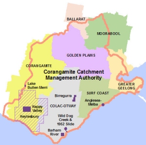
Barham River Valley and Beauty Creek (Apollo Bay)
Barwon River at Birregurra
Happy Valley (Heytesbury Region)
Heytesbury Settlement
Lake Bullen Merri
Melba Parade - Anglesea
Wild Dog Creek (Apollo Bay)
The 1952 Slide Site in the Wild Dog Creek Valley 
Target Areas and Selection of Sites.

The choice of target areas within the CCMA region where trend analysis was to be undertaken was based on risk assessment techniques which combined the nature and severity of the impact of a particular hazard with the significance of the asset under threat. A series of target areas were identified through a GIS-based desk-top study and these were further assessed in the field by members of the soil health team during late 2006.


Based on this process, a number of sites were chosen for detailed API analysis with the aim to establishing the temporal rates of occurrence of the specific hazard at each site. A list of the locations and sites chosen for analysis is contained in the following table (the maps appear at right):
2. Erosion Trend Maps 
Click on area of interest or select from list below:
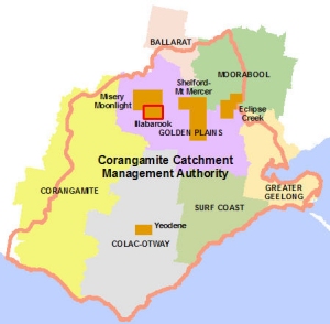
Eclipse Creek
Illabarook
Misery Moonlight
Shelford-Mt.Mercer Rd
Yeodene (Boundary Creek)
Type Location Municipality and Landscape Zone
Landslide locations and individual sites where trend analysis has been conducted Wild Dog Creek (Apollo Bay) Colac-Otway (Otway Coast)
The “1952 Slide” site in the Wild Dog Creek Valley Colac-Otway (Otway Coast)
The Heytesbury Settlement Corangamite (Curdies)
Happy Valley (Heytesbury Region) Corangamite (Curdies)
The Melba Parade Landslide at Anglesea Surf Coast (Thompsons)
Lake Bullen Merri Landslides Corangamite (just outside the boundary of CCMA)
Barham River Valley and Beauty Creek Apollo Bay Colac-Otway (Otway Coast)
Barwon River at Birregurra (incomplete to date) Colac-Otway (Upper Barwon)
Erosion locations and sites where trend analysis has been conducted Misery Moonlight Golden Plains (Woady Yaloak)
Eclipse Creek Golden Plains and Moorabool (Moorabool)
Shelford Mt Mercer Rd Golden Plains (Leigh)
Yeodene (Boundary Creek) Colac-Otway (Upper Barwon)
Illabarook  Golden Plains (Woady Yaloak)

Top of Page


Summary of Results

Detailed results of the tend mapping analysis for each site are contained on the individual web pages and include dates of the initial and subsequent mapping windows and statistics for observed increases and/or decreases in the spatial extent of erosion.

Analysis of landslides trends showed significantly different rates depending on geological conditions and land use and management practices. A significant increase in landslides in the Heytesbury region occurred almost immediately after the clearing of native forest and bush in the mid 1950’s where the spatial extent of landslides in this region has increased over 800% over the 45 year period of analysis.

The case of Wild Dog Creek near Apollo Bay in the Otway Ranges is quite different. Initial analysis showed over 76% of the total study area had been affected by landsliding of some form in the past. However on average, only a small percentage (1 to 2%) of the study area was observed to be active in the temporal snapshots except for the very wet year of 1952. Analysis of the 1952 aerials showed a marked increase the number and extent of active landslides with the percentage of the affected study area increasing to approximately 6%. A review of the rainfall records around this time confirms a sequence of significantly wetter days and months years in 1951 and 1952.

Other rates of occurrences vary as the geology and the time-span changes for various locations.

Incidences of erosion also vary significantly. Erosion type (i.e. gully or sheet erosion) can be very different for the same locations whilst it is also postulated that climatic conditions have a significant effect on the temporal extent of erosion especially during times of drought when ground cover is reduced.

Analysis in the Illabarook area showed a fluctuating change from the initial base mapping date of 1970. Sheet erosion increased by over 200% in 1981 from the initial extent in 1970 but had receded to an increase of only 38% in 1990 when compared with the 1970 base extent. A similar type of fluctuation was also noted for gully erosion although the magnitudes of the variations were quite different.

Assessment in the Eclipse Creek area showed a 170% increase in the extent of sheet erosion from 1985 to 2000 but only a 12% increase over the same period in gully erosion.

Conversely, trend analysis of erosion along the Shelford–Rokewood Rd indicated an approximate 50% decrease in sheet erosion from 1970 to 2000 and a decrease of 37% in gully erosion over the same period. It is thought that good land management practice and/or the invasive migration of some weed species into the area may have had a significant impact on the extent of erosion during the temporal window analysed.


Application for Intended Use

The purpose of these trend mapping studies is to interpret the location and extent of erosion and/or landslides and to document the rate at which these hazards have increased or decreased over a stated period of time. While all care has been taken to record data as accurately as possible, the data custodians do not guarantee that the data is accurate, up to date, complete or suitable for any purpose. The data custodians disclaim all other liability for all loss, damage, cost or expense incurred by any person as a result of relying on the data.
Disclaimer

Top of Page

Produced by AS Miner Geotechnical
Copyright 2007