Victorian Resources Online (archived)
Corangamite Region Soil Pits
A number of soil pits have been characterised and described associated with various projects within the Department of Environment and Primary Industries and previous Departments.
In this region, most soil pits were characterised as part of the 'Wet Soils' (1998), 'South-West Gas Pipeline Survey' (1999), 'Raised Bed Cropping Soils' (1999) and 'Corangamite Land Resource Assessment' (2003) projects.
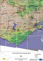 Corangamite Region Soil Pits - Mapsheet Grid. | This is a clickable map of the Corangamite Region of Victoria. Click on this regional map to access the Corangamite mapsheet grid that highlights the soil pits characterised in this region. |
Corangamite Region Soil Pit Sites